Capilla del Colegio María Auxiliadora
Capilla del Colegio María Auxiliadora is a church in San Fernando Department, Chaco. Capilla del Colegio María Auxiliadora is situated nearby to the church Iglesia Familia de Fe, as well as near the college Instituto Superior Educacion Y Trabajo.| Tap on a place to explore it |
Places of Interest Nearby
Highlights include Resistencia train station and Museo de Medios de Comunicación Raúl Berneri.
Resistencia train station
Railway station

Photo: Pertile, CC BY-SA 3.0.
Resistencia train station is a railway station, which is situated 580 metres southwest of Capilla del Colegio María Auxiliadora.
Museo de Medios de Comunicación Raúl Berneri
Museum

Photo: Pertile, CC BY-SA 4.0.
Museo de Medios de Comunicación Raúl Berneri is a museum, which is situated 1¼ km northwest of Capilla del Colegio María Auxiliadora.
Resistencia Cathedral
Church
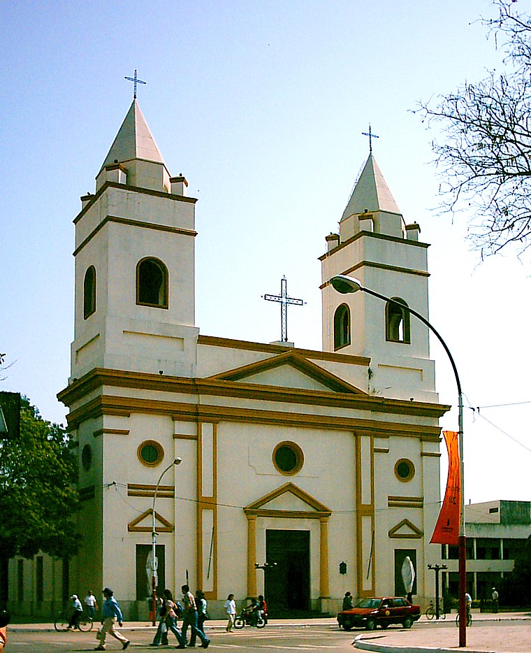
Photo: Fernandopascullo, Public domain.
The St. Ferdinand the King Cathedral, also called Resistencia Cathedral is a Roman Catholic cathedral in Resistencia, Argentina. It is the seat of the Archdiocese of Resistencia, and the head of an ecclesiastical province which covers the Argentine provinces of Chaco and Formosa. Resistencia Cathedral is situated 1½ km northwest of Capilla del Colegio María Auxiliadora.
Places in the Area
Nearby places include Resistencia and La Liguria.
Resistencia

Photo: Bleff, CC BY-SA 3.0.
Resistencia is a city in Chaco, Argentina. It is known as City of Sculptures, with more than 600 sculptures across the city. Bienal Internacional de Esculturas is the main attraction, in a week you can see how artists from all over the world make sculptures.
La Liguria
Neighborhood
La Liguria is a village and municipality in Chaco Province in northern Argentina. La Liguria is situated 3 km southeast of Capilla del Colegio María Auxiliadora.
Barranqueras
Town
 Barranqueras is a city in the southeast of the province of Chaco, Argentina, on a small tributary river on the right-hand-side shore of the Paraná River, only 7 km from the provincial capital Resistencia and within its metropolitan area. Barranqueras is situated 5 km southeast of Capilla del Colegio María Auxiliadora.
Capilla del Colegio María Auxiliadora
- Type: Church
- Denomination: Catholic
- Categories: place of worship and religion
- Location: San Fernando Department, Chaco, Argentina, South America
- View on OpenStreetMap
Latitude
-27.46059° or 27° 27′ 38″ southLongitude
-58.97641° or 58° 58′ 35″ westOpen location code
5843G2QF+QCOpenStreetMap ID
way 211545145OpenStreetMap feature
amenity=place_of_worshipOpenStreetMap attribute
denomination=catholic
This page is based on OpenStreetMap, Wikidata, and Wikimedia Commons.
We’d love your help improving our open data sources. Thank you for contributing.
Satellite Map
Discover Capilla del Colegio María Auxiliadora from above in high-definition satellite imagery.
Notable Places Nearby
Highlights include Iglesia Familia de Fe and Instituto Superior Educacion Y Trabajo.
Nearby Places
Explore places such as Unidad Educativa de Gestión Privada 21 María Auxiliadora and 9 de Julio y Julio E. Acosta.
Chaco: Must-Visit Destinations
Delve into Resistencia, Formosa, Clorinda, and Río Pilcomayo National Park.
Curious Churches to Discover
Uncover intriguing churches from every corner of the globe.
About Mapcarta. Data © OpenStreetMap contributors and available under the Open Database License". Text is available under the CC BY-SA 4.0 license, except for photos, directions, and the map. Photo: Wikimedia, CC0.