St. Edwards Roman Catholic Church
St. Edwards Roman Catholic Church is a church in Town of Medfield, Norfolk, Massachusetts which is located on Spring Street. St. Edwards Roman Catholic Church is situated nearby to the recreation area Kingsbury Pond, as well as near the nature reserve Charles River Natural Valley Storage Area.| Tap on a place to explore it |
- Type: Church
- Denomination: Roman Catholic
- Address: 133 Spring Street
Places of Interest Nearby
Highlights include Medfield Town Pound and Dwight–Derby House.
Medfield Town Pound
Historic site
 Medfield Town Pound is a historic site, which is situated 2,800 feet southeast of St. Edwards Roman Catholic Church.
Dwight–Derby House
Museum
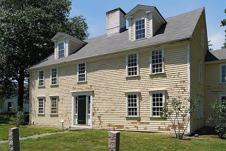
Photo: Marcbela, Public domain.
The Dwight–Derby House is at 7 Frairy Street in Medfield, Massachusetts. The Oxford Dendrochronology Laboratory took samples of the house frame in 2007 and determined that the earliest, southwest portion of the house was built in 1697, and an addition was built to the east in 1713. Dwight–Derby House is situated 4,200 feet northwest of St. Edwards Roman Catholic Church.
Peak House
Museum

Photo: Kzirkel, CC BY-SA 4.0.
Peak House Heritage Center is a historic site located in Medfield, Massachusetts. According to tradition, the original house was built in 1651 by Benjamin Clark, was burned during the King Philip's War on February 21, 1676, and was rebuilt ca. Peak House is situated 1 mile north of St. Edwards Roman Catholic Church.
Places in the Area
Nearby places include Medfield and Millis.
Medfield

Photo: Wikimedia, CC BY-SA 2.0.
Medfield is a town of 13,000 people in Massachusetts. Medfield was first settled by Anglo-Americans in 1649 after the land was taken from the Neponset Native Americans.
Millis
Town
 Franklin is a city of 37,000 in Massachusetts. Bellingham is a town with a population of 17,000. Birthplace of noted author William Taylor Adams, also known as Oliver Optic. Millis is situated 3 miles west of St. Edwards Roman Catholic Church.
Walpole
 Walpole is a town in Norfolk County, Massachusetts, United States. Walpole Town, as the Census refers to it, is located approximately 18 miles south of downtown Boston, Massachusetts, and 30 miles north of Providence, Rhode Island.
St. Edwards Roman Catholic Church
- Categories: building, place of worship, and religion
- Location: Town of Medfield, Norfolk, Massachusetts, New England, United States, North America
- View on OpenStreetMap
Latitude
42.17692° or 42° 10′ 37″ northLongitude
-71.30164° or 71° 18′ 6″ westOpen location code
87JC5MGX+Q8OpenStreetMap ID
way 214522782OpenStreetMap feature
amenity=place_of_worshipOpenStreetMap feature
building=churchOpenStreetMap attribute
denomination=roman_catholic
This page is based on OpenStreetMap, Wikidata, and Wikimedia Commons.
We’d love your help improving our open data sources. Thank you for contributing.
Satellite Map
Discover St. Edwards Roman Catholic Church from above in high-definition satellite imagery.
Places with the Same Name
Discover other places named “St. Edwards Roman Catholic Church”.
Notable Places Nearby
Highlights include Kingsbury Pond and Charles River Natural Valley Storage Area.
Nearby Places
Explore places such as Olde Village Square Condominiums and Sunoco.
Massachusetts: Must-Visit Destinations
Delve into Boston, Cambridge, Springfield, and Downtown Boston.
Curious Churches to Discover
Uncover intriguing churches from every corner of the globe.
About Mapcarta. Data © OpenStreetMap contributors and available under the Open Database License". Text is available under the CC BY-SA 4.0 license, except for photos, directions, and the map. Photo: papadunes, CC BY-SA 3.0.