Centro de Salud de Siete Infantes de Lara
Centro de Salud de Siete Infantes de Lara is a clinic in Logroño, La Rioja. Centro de Salud de Siete Infantes de Lara is situated nearby to the post office Oficina de Correos, as well as near the lake Estanque de La Laguna.| Tap on a place to explore it |
Places of Interest Nearby
Highlights include 7 Infants Cinemas and Fuente de los Ilustres, Logroño.
7 Infants Cinemas
Movie theater

Photo: Jynus, CC BY-SA 4.0.
7 Infants Cinemas is a movie theater, which is situated 310 metres south of Centro de Salud de Siete Infantes de Lara.
Fuente de los Ilustres, Logroño
Fountain

Photo: Pacoperez6, CC BY-SA 4.0.
Fuente de los Ilustres, Logroño is a fountain, which is situated 1 km northeast of Centro de Salud de Siete Infantes de Lara.
Palacio de los Deportes de La Rioja
Sports venue
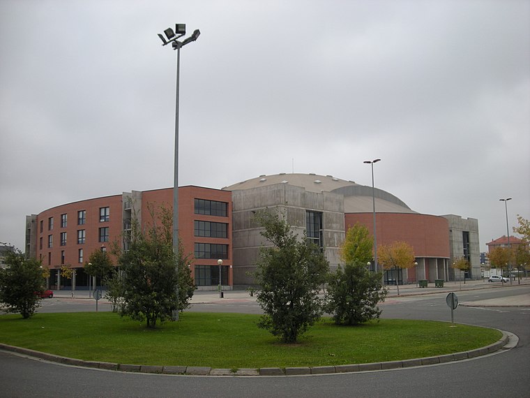
Photo: Pablovp, CC BY-SA 4.0.
Palacio de los Deportes de La Rioja is an arena in Logroño, Spain. The arena holds 3,809 people, expandable to 4,500 people with additional seats. It is primarily used for handball and basketball. This is the home arena of CB Ciudad de Logroño and CB Clavijo. Palacio de los Deportes de La Rioja is situated 790 metres southeast of Centro de Salud de Siete Infantes de Lara.
Places in the Area
Nearby places include La Estrella (Logroño) and Puente Madre.
La Estrella (Logroño)
Suburb
 La Estrella (Logroño) is a suburb, which is situated 3 km east of Centro de Salud de Siete Infantes de Lara.
Puente Madre
Neighborhood

Photo: Jynus, CC BY-SA 4.0.
Puente Madre is a village in the municipality of Villamediana de Iregua, in the province and autonomous community of La Rioja, Spain. As of 2019 had a population of 194 people. Puente Madre is situated 3½ km east of Centro de Salud de Siete Infantes de Lara.
Los Lirios
Quarter
 Los Lirios is a quarter, which is situated 3½ km east of Centro de Salud de Siete Infantes de Lara.
Centro de Salud de Siete Infantes de Lara
- Type: Clinic
- Categories: health care and building
- Location: Logroño, La Rioja, Northern Spain, Spain, Iberia, Europe
- View on OpenStreetMap
Latitude
42.45909° or 42° 27′ 33″ northLongitude
-2.46104° or 2° 27′ 40″ westOpen location code
8CJVFG5Q+JHOpenStreetMap ID
way 222283787OpenStreetMap feature
amenity=clinicOpenStreetMap feature
building=yesOpenStreetMap feature
healthcare=clinic
This page is based on OpenStreetMap, Wikidata, and Wikimedia Commons.
We’d love your help improving our open data sources. Thank you for contributing.
Satellite Map
Discover Centro de Salud de Siete Infantes de Lara from above in high-definition satellite imagery.
Notable Places Nearby
Highlights include Oficina de Correos and Estanque de La Laguna.
Nearby Places
Explore places such as Cafetería Tarasca and Promosalud.
La Rioja: Must-Visit Destinations
Delve into Santo Domingo de la Calzada, Haro, San Millán de la Cogolla, and Ezcaray.
Curious Clinics to Discover
Uncover intriguing clinics from every corner of the globe.
About Mapcarta. Data © OpenStreetMap contributors and available under the Open Database License". Text is available under the CC BY-SA 4.0 license, except for photos, directions, and the map. Photo: Pablovp, CC BY-SA 4.0.