Major Gas/Convenience
Major Gas/Convenience is a convenience store in Dallas, Texas. Major Gas/Convenience is situated nearby to the hospital Scottish Rite for Children, as well as near the sports venue Reverchon Park Recreation Center.| Tap on a place to explore it |
Places of Interest Nearby
Highlights include Scottish Rite for Children and American Airlines Center.
Scottish Rite for Children
Hospital
Scottish Rite for Children, located in Dallas, is a pediatric hospital specializing in the treatment of orthopedic conditions and sports injuries, as well as certain related arthritic and neurological disorders and learning disorders, such as dyslexia. Scottish Rite for Children is situated 790 feet southwest of Major Gas/Convenience.
American Airlines Center
Stadium
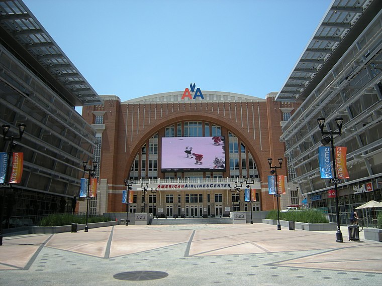
Photo: Jmabel, CC BY-SA 3.0.
American Airlines Center is a multi-purpose indoor arena located in the Victory Park neighborhood in downtown Dallas, Texas. The arena serves as the home of the Dallas Stars of the National Hockey League and Dallas Mavericks of the National Basketball Association. American Airlines Center is situated 1 mile south of Major Gas/Convenience.
Reverchon Park
Park

Photo: Drumguy8800, CC BY-SA 3.0.
Reverchon Park is a public park in the Oak Lawn area of Dallas, Texas. It was named for the French botanist Julien Reverchon. The park lies along Turtle Creek, a tributary of the Trinity River. Its main entrance is at Maple Avenue and Turtle Creek Boulevard.
Places in the Area
Nearby places include Design District and Arts District.
Design District
Quarter
The Design District is a neighborhood in central Dallas, Texas, just northwest of Downtown. It is bordered by I-35E on the north and east, Wycliff Avenue and the Trinity River levee on the west, and Continental Avenue on the south.
Arts District
Neighborhood

Photo: Luis Tamayo, CC BY-SA 2.0.
The Arts District is a performing and visual arts district in downtown Dallas, Texas. The district is 118 acres large and is home to some of Dallas's most significant cultural landmarks including facilities for visual, performing, and developing arts.
West End Historic District
Neighborhood

Photo: Drumguy8800, CC BY-SA 3.0.
The West End Historic District of Dallas, Texas, is a historic district that includes a 67.5-acre area in northwest downtown, generally north of Commerce, east of I-35E, west of Lamar and south of the Woodall Rodgers Freeway. West End Historic District is situated 2 miles south of Major Gas/Convenience.
Major Gas/Convenience
- Type: Convenience store
- Categories: building, shop, retail building, and food
- Location: Dallas, Texas, United States, North America
- View on OpenStreetMap
Latitude
32.80406° or 32° 48′ 15″ northLongitude
-96.81344° or 96° 48′ 48″ westOpen location code
8645R53P+JJOpenStreetMap ID
way 222817079OpenStreetMap feature
building=retailOpenStreetMap feature
shop=convenience
This page is based on OpenStreetMap, Wikidata, and Wikimedia Commons.
We’d love your help improving our open data sources. Thank you for contributing.
Satellite Map
Discover Major Gas/Convenience from above in high-definition satellite imagery.
Notable Places Nearby
Highlights include Reverchon Park Recreation Center and Cobb Stadium.
Nearby Places
Explore places such as Maple @ Oak Lawn - S - FS and Maple @ Oak Lawn - N - NS.
Texas: Must-Visit Destinations
Delve into Houston, Austin, Dallas, and San Antonio.
Curious Convenience Stores to Discover
Uncover intriguing convenience stores from every corner of the globe.
About Mapcarta. Data © OpenStreetMap contributors and available under the Open Database License". Text is available under the CC BY-SA 4.0 license, except for photos, directions, and the map. Photo: Wikimedia, CC0.