Chemistry Safety Building
Chemistry Safety Building is an university building in Town of New Haven, South Central Connecticut Planning Region, Connecticut which is located on Edwards Street. Chemistry Safety Building is situated nearby to the university building Kline Biology Tower, as well as near Leitner Family Observatory and Planetarium.| Tap on a place to explore it |
Places of Interest Nearby
Highlights include Ingalls Rink and Beinecke Rare Book and Manuscript Library.
Ingalls Rink
Sports venue

Photo: Carol M. Highsmith, Public domain.
David S. Ingalls Rink is a hockey rink in New Haven, Connecticut, designed by architect Eero Saarinen and built between 1953 and 1958 for Yale University. Ingalls Rink is situated 1,100 feet southwest of Chemistry Safety Building.
Beinecke Rare Book and Manuscript Library
Library
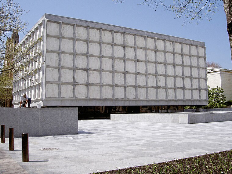
Photo: Wikimedia, Public domain.
The Beinecke Rare Book & Manuscript Library is the rare book library and literary archive of the Yale University Library in New Haven, Connecticut. It is one of the largest buildings in the world dedicated to rare books and manuscripts and is one of the largest collections of such texts. Beinecke Rare Book and Manuscript Library is situated 3,100 feet southwest of Chemistry Safety Building.
Kline Biology Tower
University building

Photo: Wikimedia, Public domain.
Kline Tower is a skyscraper in New Haven, Connecticut. Formerly Kline Biology Tower, this building is currently the tallest on the Yale University campus and the sixth-tallest building in New Haven. Kline Biology Tower is situated 630 feet south of Chemistry Safety Building.
Places in the Area
Nearby places include Hillhouse Avenue and Prospect Hill Historic District.
Hillhouse Avenue
Neighborhood
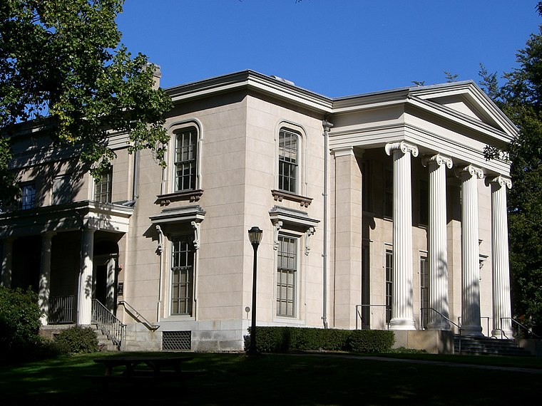 Hillhouse Avenue is a street in New Haven, Connecticut, famous for its many nineteenth century mansions, including the president's house at Yale University.
Prospect Hill Historic District
Neighborhood

Photo: Emporostheoros, Public domain.
The Prospect Hill Historic District is an irregularly-shaped 185-acre historic district in New Haven, Connecticut. The district encompasses most of the residential portion of the Prospect Hill neighborhood.
Orange Street Historic District
Neighborhood

Photo: Emporostheoros, Public domain.
The Orange Street Historic District encompasses a large residential in the East Rock section of New Haven, Connecticut. Roughly bounded by Orange, Cottage, Eagle, State, and Audubon Streets, this area saw growth between about 1830 and 1900, and includes a broad diversity of well-preserved 19th-century residential structures.
Chemistry Safety Building
- Type: University building
- Address: 350 Edwards Street, New Haven, CT 06511
- Categories: building and education
- Location: Town of New Haven, South Central Connecticut Planning Region, Connecticut, New England, United States, North America
- View on OpenStreetMap
Latitude
41.31895° or 41° 19′ 8″ northLongitude
-72.92196° or 72° 55′ 19″ westOperator
Yale UniversityOpen location code
87H9839H+H6OpenStreetMap ID
way 228473358OpenStreetMap feature
building=university
This page is based on OpenStreetMap, Wikidata, and Wikimedia Commons.
We’d love your help improving our open data sources. Thank you for contributing.
Satellite Map
Discover Chemistry Safety Building from above in high-definition satellite imagery.
Notable Places Nearby
Highlights include Leitner Family Observatory and Planetarium and Sachem’s Wood.
Nearby Places
Explore places such as Electron Accelerator Laboratory and Kline Chemistry Laboratory.
Connecticut: Must-Visit Destinations
Delve into Hartford, New Haven, Bridgeport, and Stamford.
Curious Places to Discover
Uncover intriguing places from every corner of the globe.
About Mapcarta. Data © OpenStreetMap contributors and available under the Open Database License". Text is available under the CC BY-SA 4.0 license, except for photos, directions, and the map. Photo: Wikimedia, CC0.