Centre d’incendie et de secours de Saint-Maurice-sur-Aveyron
Centre d’incendie et de secours de Saint-Maurice-sur-Aveyron is a fire station in Saint-Maurice-sur-Aveyron, Arrondissement of Montargis, Centre-Val de Loire. Centre d’incendie et de secours de Saint-Maurice-sur-Aveyron is situated nearby to the town hall Mairie de Saint-Maurice-sur-Aveyron, as well as near the church Église Saint-Maurice de Saint-Maurice-sur-Aveyron.| Tap on a place to explore it |
Places of Interest Nearby
Highlights include Église Saint-Maurice de Saint-Maurice-sur-Aveyron and Fontainejean Abbey.
Église Saint-Maurice de Saint-Maurice-sur-Aveyron
Church

Photo: Basicdesign, CC BY-SA 3.0.
Église Saint-Maurice de Saint-Maurice-sur-Aveyron is a church, which is situated 360 metres south of Centre d’incendie et de secours de Saint-Maurice-sur-Aveyron.
Fontainejean Abbey
Ruins

Photo: Wikimedia, Public domain.
Fontainejean Abbey, otherwise Fontaine-Jean Abbey, was a Cistercian monastery in the commune of Saint-Maurice-sur-Aveyron in the Gâtinais in the département of Loiret, France. Fontainejean Abbey is situated 2½ km east of Centre d’incendie et de secours de Saint-Maurice-sur-Aveyron.
Places in the Area
Nearby places include Châtillon-Coligny and Montbouy.
Châtillon-Coligny
Village

Photo: Alvaro, CC BY-SA 3.0.
Châtillon-Coligny is a commune in the Loiret department in north-central France. The Loing and the Briare Canal run through the town. Châtillon-Coligny is situated 7 km southwest of Centre d’incendie et de secours de Saint-Maurice-sur-Aveyron.
Montbouy
Village
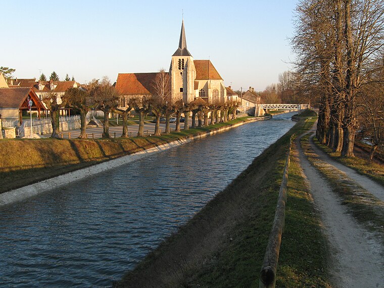
Photo: Alvaro, CC BY-SA 3.0.
Montbouy is a commune in the Loiret department in north-central France. Montbouy is situated 8 km west of Centre d’incendie et de secours de Saint-Maurice-sur-Aveyron.
Chambeugle
Village

Photo: Basicdesign, CC BY-SA 3.0.
Chambeugle is a former commune in the Yonne department in Bourgogne-Franche-Comté in north-central France. On 1 January 2016, it was merged into the new commune of Charny-Orée-de-Puisaye. Chambeugle is situated 9 km east of Centre d’incendie et de secours de Saint-Maurice-sur-Aveyron.
Centre d’incendie et de secours de Saint-Maurice-sur-Aveyron
- Type: Fire station
- Also known as: “CPI Saint-Maurice-sur-Aveyron”
- Category: building
- Location: Saint-Maurice-sur-Aveyron, Arrondissement of Montargis, Loiret, Centre-Val de Loire, France, Europe
- View on OpenStreetMap
Latitude
47.85197° or 47° 51′ 7″ northLongitude
2.9265° or 2° 55′ 35″ eastOperator
SDIS 45Open location code
8FV4VW2G+QHOpenStreetMap ID
way 240176701OpenStreetMap feature
amenity=fire_stationOpenStreetMap feature
building=fire_station
This page is based on OpenStreetMap, Wikidata, and Wikimedia Commons.
We’d love your help improving our open data sources. Thank you for contributing.
Satellite Map
Discover Centre d’incendie et de secours de Saint-Maurice-sur-Aveyron from above in high-definition satellite imagery.
Notable Places Nearby
Highlights include Saint-Maurice-sur-Aveyron and Mairie de Saint-Maurice-sur-Aveyron.
Nearby Places
Explore places such as Au four et au moulin and Garage Gavaini.
Centre-Val de Loire: Must-Visit Destinations
Delve into Orléans, Tours, Chartres, and Bourges.
Curious Fire Stations to Discover
Uncover intriguing fire stations from every corner of the globe.
About Mapcarta. Data © OpenStreetMap contributors and available under the Open Database License". Text is available under the CC BY-SA 4.0 license, except for photos, directions, and the map. Photo: PMRMaeyaert, CC BY-SA 3.0.