plastoNet
plastoNet is an industrial building in Wuppertal, Düsseldorf, North Rhine-Westphalia which is located on Vor der Beule. plastoNet is situated nearby to the health club Trainingszentrum Mutig & Stark, as well as near the water park Freibad Mählersbeck.| Tap on a place to explore it |
Places of Interest Nearby
Highlights include Haus Abendfrieden and Villa Halstenbach.
Haus Abendfrieden
Social service facility

Photo: Atamari, CC BY-SA 3.0.
Haus Abendfrieden is a social service facility, which is situated 640 metres southwest of plastoNet.
Villa Halstenbach
Building
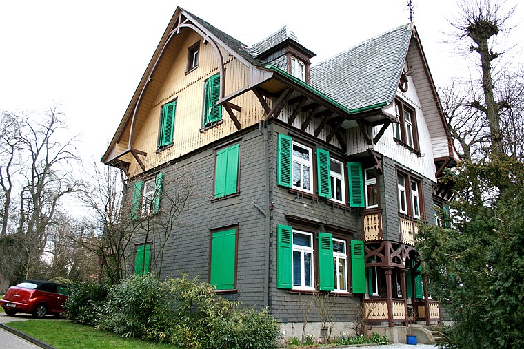
Photo: Wikimedia, CC BY-SA 3.0.
Villa Halstenbach is a building, which is situated 480 metres southwest of plastoNet.
Gesamtschule Langerfeld
School

Photo: Im Fokus, CC BY-SA 4.0.
Gesamtschule Langerfeld is a school, which is situated 800 metres southeast of plastoNet.
Places in the Area
Nearby places include Langerfeld and Nächstebreck.
Langerfeld
Suburb

Photo: A.Savin, CC BY-SA 3.0.
Langerfeld is a borough of the German city of Wuppertal. On 24 June 2018, an explosion in the area damaged an apartment complex and surroundings. The blast was powerful and destroyed the three top floors of the block and a parked car.

Barmen
Suburb

Photo: Manos, CC BY-SA 3.0.
Barmen is a former industrial metropolis of the region of Bergisches Land, Germany, which merged with four other towns in 1929 to form the city of Wuppertal. Barmen is situated 3 km southwest of plastoNet.
plastoNet
- Type: Industrial building
- Address: Vor der Beule 25, Wuppertal, 42277
- Categories: building and industry
- Location: Wuppertal, Düsseldorf, Bergisches Land, North Rhine-Westphalia, Germany, Central Europe, Europe
- View on OpenStreetMap
Latitude
51.28936° or 51° 17′ 22″ northLongitude
7.22891° or 7° 13′ 44″ eastLevels
2Open location code
9F3976QH+PHOpenStreetMap ID
way 241098168OpenStreetMap feature
building=industrial
This page is based on OpenStreetMap, Wikidata, and Wikimedia Commons.
We’d love your help improving our open data sources. Thank you for contributing.
Satellite Map
Discover plastoNet from above in high-definition satellite imagery.
Notable Places Nearby
Highlights include Trainingszentrum Mutig & Stark and Freibad Mählersbeck.
Nearby Places
Explore places such as Carl Wilhelm Cleff and Seltra Natursteinhandel.
Bergisches Land: Must-Visit Destinations
Delve into Solingen, Bergisch Gladbach, Remscheid, and Gummersbach.
Curious Industrial Buildings to Discover
Uncover intriguing industrial buildings from every corner of the globe.
About Mapcarta. Data © OpenStreetMap contributors and available under the Open Database License". Text is available under the CC BY-SA 4.0 license, except for photos, directions, and the map. Photo: Wikimedia, CC0.