Caritas Bezirksstelle
Caritas Bezirksstelle is a social service facility in Berlin, Berlin. Caritas Bezirksstelle is situated nearby to the health club Yogatribe, as well as near the museum Magicum.| Tap on a place to explore it |
- Email: sucht-gr.hamburger@caritas-berlin.de
- Type: Social service facility
- Also known as: “Don Bosco-Heim” and “Haus der Caritas”
Places of Interest Nearby
Highlights include Pergamon Museum and Neues Museum.
Pergamon Museum
Museum
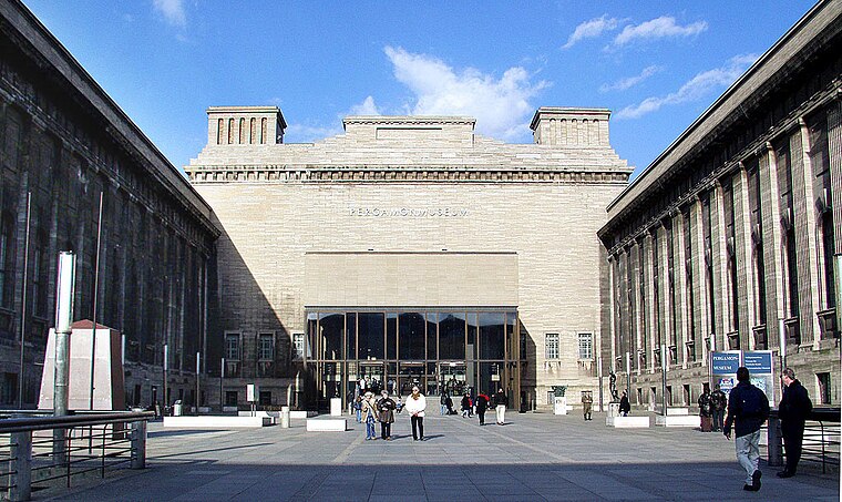
Photo: Wikimedia, CC BY-SA 4.0.
The Pergamon Museum is a listed building on the Museum Island in the historic centre of Berlin, Germany. It was built from 1910 to 1930 by order of Emperor Wilhelm II and according to plans by Alfred Messel and Ludwig Hoffmann in Stripped Classicism style. Pergamon Museum is situated 440 metres south of Caritas Bezirksstelle.
Neues Museum
Museum

Photo: Joyofmuseums, CC BY-SA 4.0.
The Neues Museum is a listed building on the Museum Island in the historic centre of Berlin, Germany. Built from 1843 to 1855 by order of King Frederick William IV of Prussia in Neoclassical and Renaissance Revival styles, it is considered as the major work of Friedrich August Stüler. Neues Museum is situated 490 metres south of Caritas Bezirksstelle.
Museum Island

Photo: Der Wolf im Wald, CC BY-SA 3.0.
The Museum Island is a museum complex on the northern part of Spree Island in the historic heart of Berlin, Germany. It is one of the capital's most visited sights and one of the most important museum sites in Europe.
Places in the Area
Nearby places include Spandauer Vorstadt and Scheunenviertel.
Spandauer Vorstadt
Quarter
Spandauer Vorstadt is a historic district in what is now the Mitte district of Berlin.
Scheunenviertel
Neighborhood
Scheunenviertel is a neighborhood of Mitte in the centre of Berlin. It is situated to the north of the medieval Altberlin area, east of the Rosenthaler Straße and Hackescher Markt.
Alt-Berlin
Locality

Photo: Sludge G, CC BY-SA 2.0.
Alt-Berlin, also spelled Altberlin, is a neighborhood, situated in the Berliner locality of Mitte, part of the homonymous borough. In the 13th century it was the sister town of the old Cölln, located on the northern Spree Island in the Margraviate of Brandenburg.
Caritas Bezirksstelle
- Categories: building and residential building
- Location: Berlin, Berlin, Stadt, Berlin, Germany, Central Europe, Europe
- View on OpenStreetMap
Latitude
52.52456° or 52° 31′ 28″ northLongitude
13.39891° or 13° 23′ 56″ eastLevels
4Operator
Caritasverband für das Erzbistum Berlin e.V.Open location code
9F4MG9FX+RHOpenStreetMap ID
way 243911404OpenStreetMap feature
amenity=social_facilityOpenStreetMap feature
building=residential
This page is based on OpenStreetMap, Wikidata, and Wikimedia Commons.
We’d love your help improving our open data sources. Thank you for contributing.
Satellite Map
Discover Caritas Bezirksstelle from above in high-definition satellite imagery.
Notable Places Nearby
Highlights include Magicum and Kisuna.
Nearby Places
Explore places such as Arnold David Koller and [U25] Berlin.
Berlin: Must-Visit Destinations
Delve into Mitte, East Central, City West, and East Berlin.
Curious Social Service Facilities to Discover
Uncover intriguing social service facilities from every corner of the globe.
About Mapcarta. Data © OpenStreetMap contributors and available under the Open Database License". Text is available under the CC BY-SA 4.0 license, except for photos, directions, and the map. Photo: Berthold Werner, CC BY-SA 3.0.