Lagerplatz Straßen- und Grünflächenamt Marzahn Hellersdorf
Lagerplatz Straßen- und Grünflächenamt Marzahn Hellersdorf is a landfill in Berlin, Berlin. Lagerplatz Straßen- und Grünflächenamt Marzahn Hellersdorf is situated nearby to the chapel Friedhof Biesdorf, as well as near the peak Biesdorfer Höhe.| Tap on a place to explore it |
Places of Interest Nearby
Highlights include Biesdorfer Höhe and Berlin Wuhletal station.

Berlin Wuhletal station
Railway station

Photo: Jcornelius, CC BY-SA 3.0.
Wuhletal is a railway station in the Kaulsdorf district of the Marzahn-Hellersdorf borough of Berlin. It is served by the S-Bahn line S5 and the U-Bahn line U5. Berlin Wuhletal station is situated 660 metres northeast of Lagerplatz Straßen- und Grünflächenamt Marzahn Hellersdorf.
Biesdorf Palace
Museum
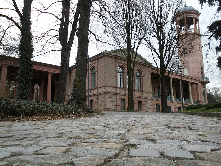
Photo: Odor, CC BY-SA 3.0.
The Biesdorf Palace is a Neoclassical-style building in Marzahn-Hellersdorf, Berlin. Constructed in 1868, Werner von Siemens acquired the palace in 1887. Biesdorf Palace is situated 750 metres west of Lagerplatz Straßen- und Grünflächenamt Marzahn Hellersdorf.
Places in the Area
Nearby places include Sewanviertel and Prinzenviertel.
Sewanviertel
Neighborhood

Photo: Wikimedia, CC BY-SA 3.0 de.
Sewanviertel is a neighborhood, which is situated 4 km west of Lagerplatz Straßen- und Grünflächenamt Marzahn Hellersdorf.
Prinzenviertel
Quarter

Photo: Michael G. Schroeder, CC BY-SA 3.0.
Prinzenviertel is a quarter, which is situated 4½ km southwest of Lagerplatz Straßen- und Grünflächenamt Marzahn Hellersdorf.
Weitlingkiez
Quarter

Photo: 44penguins, CC BY 3.0.
Weitlingkiez is a quarter, which is situated 4½ km west of Lagerplatz Straßen- und Grünflächenamt Marzahn Hellersdorf.
Lagerplatz Straßen- und Grünflächenamt Marzahn Hellersdorf
- Type: Landfill
- Location: Berlin, Berlin, Stadt, Berlin, Germany, Central Europe, Europe
- View on OpenStreetMap
Latitude
52.5083° or 52° 30′ 30″ northLongitude
13.56846° or 13° 34′ 7″ eastOpen location code
9F4MGH59+89OpenStreetMap ID
way 247168054OpenStreetMap feature
landuse=landfill
This page is based on OpenStreetMap, Wikidata, and Wikimedia Commons.
We’d love your help improving our open data sources. Thank you for contributing.
Satellite Map
Discover Lagerplatz Straßen- und Grünflächenamt Marzahn Hellersdorf from above in high-definition satellite imagery.
Notable Places Nearby
Highlights include Friedhof Biesdorf and Große Maskenbank.
Nearby Places
Explore places such as Autohaus Körner and Hellweg.
Berlin: Must-Visit Destinations
Delve into Mitte, East Central, City West, and East Berlin.
Curious Landfills to Discover
Uncover intriguing landfills from every corner of the globe.
About Mapcarta. Data © OpenStreetMap contributors and available under the Open Database License". Text is available under the CC BY-SA 4.0 license, except for photos, directions, and the map. Photo: Berthold Werner, CC BY-SA 3.0.