Übungsplatz Feuerwehr Lüchow
Übungsplatz Feuerwehr Lüchow is a grassland in Lüchow (Wendland), Lüchow-Dannenberg, Lower Saxony. Übungsplatz Feuerwehr Lüchow is situated nearby to the fire station Freiwillige Feuerwehr Lüchow (Wendland) / Ortswehr Lüchow, as well as near the public building Agentur für Arbeit.| Tap on a place to explore it |
Places of Interest Nearby
Highlights include Stones Fan Museum and Johanneskirche (Lüchow).
Stones Fan Museum
Museum

Photo: Ymnes, CC BY-SA 4.0.
The Stones Fan Museum is a museum in Lüchow in Lower Saxony, Germany, that was founded in 2011. It is dedicated to the British rock band The Rolling Stones. The museum is a member of the Museumsverbund Lüchow-Dannenberg. Stones Fan Museum is situated 1 km southwest of Übungsplatz Feuerwehr Lüchow.
Johanneskirche (Lüchow)
Church
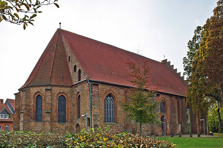
Photo: Fice, CC BY-SA 3.0.
Johanneskirche (Lüchow) is a church, which is situated 1¼ km southwest of Übungsplatz Feuerwehr Lüchow.
St. Agnes
Church

Photo: Fice, CC BY-SA 3.0.
St. Agnes is a church, which is situated 1½ km southwest of Übungsplatz Feuerwehr Lüchow.
Places in the Area
Nearby places include Lüchow and Tarmitz.
Lüchow
Town

Photo: Rabanus Flavus, CC0.
Lüchow is a city in northeastern Lower Saxony, Germany. It is the seat of the Samtgemeinde Lüchow, and is the capital of the district Lüchow-Dannenberg.


Übungsplatz Feuerwehr Lüchow
- Type: Grassland
- Location: Lüchow (Wendland), Lüchow-Dannenberg, Lower Saxony, Germany, Central Europe, Europe
- View on OpenStreetMap
Latitude
52.975° or 52° 58′ 30″ northLongitude
11.16534° or 11° 9′ 55″ eastOpen location code
9F4HX5G8+24OpenStreetMap ID
way 253238625OpenStreetMap feature
landuse=grass
This page is based on OpenStreetMap, Wikidata, and Wikimedia Commons.
We’d love your help improving our open data sources. Thank you for contributing.
Satellite Map
Discover Übungsplatz Feuerwehr Lüchow from above in high-definition satellite imagery.
Notable Places Nearby
Highlights include Freiwillige Feuerwehr Lüchow (Wendland) / Ortswehr Lüchow and Agentur für Arbeit.
Nearby Places
Explore places such as Nordic-Group and Nordic-Event.
Lower Saxony: Must-Visit Destinations
Delve into Hanover, Göttingen, Brunswick, and Wolfsburg.
Curious Grasslands to Discover
Uncover intriguing grasslands from every corner of the globe.
About Mapcarta. Data © OpenStreetMap contributors and available under the Open Database License". Text is available under the CC BY-SA 4.0 license, except for photos, directions, and the map. Photo: Danapit, CC BY-SA 3.0.