La Iglesia de Jesucristo de los Santos de los Últimos Días
La Iglesia de Jesucristo de los Santos de los Últimos Días is a church in Capital Department, San Juan. La Iglesia de Jesucristo de los Santos de los Últimos Días is situated nearby to the park Paseo Villa Yupanqui, as well as near Juventudes Argentinas.| Tap on a place to explore it |
Places of Interest Nearby
Highlights include Estadio Ingeniero Hilario Sánchez and Estadio Aldo Cantoni.
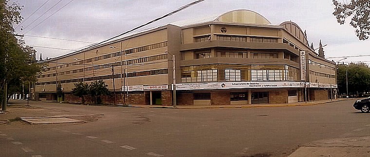
Estadio Ingeniero Hilario Sánchez
Pitch

Photo: Dfcs, CC BY-SA 4.0.
Estadio Ingeniero Hilario Sánchez is a football stadium in the city of San Juan in Argentina. It is owned and operated by C.A. San Martín. With a capacity of 26,500 spectators, it is the second biggest stadium in San Juan Province after Estadio del Bicentenario. Estadio Ingeniero Hilario Sánchez is situated 2 km west of La Iglesia de Jesucristo de los Santos de los Últimos Días.
Estadio Aldo Cantoni
Stadium
 The Estadio Aldo Cantoni is an arena located in the city of San Juan, capital of San Juan Province. Inaugurated in July 1967, it is mainly use by local clubs UPCN and Obras Pocito for their home matches for the Serie A1, the top level of the Argentine men's volleyball league system. Estadio Aldo Cantoni is situated 4 km southwest of La Iglesia de Jesucristo de los Santos de los Últimos Días.
Casa Natal de Domingo Faustino Sarmiento
Museum

Photo: EagLau, CC BY-SA 4.0.
Casa Natal de Domingo Faustino Sarmiento is a museum, which is situated 3 km southwest of La Iglesia de Jesucristo de los Santos de los Últimos Días.
Places in the Area
Nearby places include San Juan and Villa Paula Albarracín de Sarmiento.
San Juan

Photo: Enrique Guardia, CC0.
San Juan is the capital city of San Juan province, in the central-west Cuyo region of Argentina, about 150 km north of Mendoza. The province has a large Triassic period fossil record, believed to be one of the largest in the world.
Villa Paula Albarracín de Sarmiento
Village
Villa Paula Albarracín de Sarmiento is a locality and the head town of the Chimbas Department, in the San Juan Province of Argentina. It is located in the northern sector of the urban agglomeration of Greater San Juan. Villa Paula Albarracín de Sarmiento is situated 3½ km northwest of La Iglesia de Jesucristo de los Santos de los Últimos Días.
Villa Krause
Town

Photo: Gonce, CC BY-SA 3.0.
Villa Krause is a city in the province of San Juan, Argentina in the Cuyo region. The city is located in the Rawson, east of the San Juan River, at 650 m above mean sea level and has a population of around 107,000 according to the 2001 census. Villa Krause is situated 8 km south of La Iglesia de Jesucristo de los Santos de los Últimos Días.
La Iglesia de Jesucristo de los Santos de los Últimos Días
- Type: Church
- Denomination: Mormon
- Categories: building, place of worship, and religion
- Location: Capital Department, San Juan, Cuyo, Argentina, South America
- View on OpenStreetMap
Latitude
-31.51442° or 31° 30′ 52″ southLongitude
-68.51022° or 68° 30′ 37″ westOpen location code
47WHFFPQ+6WOpenStreetMap ID
way 254013087OpenStreetMap feature
amenity=place_of_worshipOpenStreetMap feature
building=yesOpenStreetMap attribute
denomination=mormon
This page is based on OpenStreetMap, Wikidata, and Wikimedia Commons.
We’d love your help improving our open data sources. Thank you for contributing.
Satellite Map
Discover La Iglesia de Jesucristo de los Santos de los Últimos Días from above in high-definition satellite imagery.
Places with the Same Name
Discover other places named “La Iglesia de Jesucristo de los Santos de los Últimos Días”.
Notable Places Nearby
Highlights include La Iglesia de Jesucristo de los Santos de los Últimos Días and Paseo Villa Yupanqui.
Nearby Places
Explore places such as Barrio Bandera Argentina and Necochea y Lucero.
San Juan: Must-Visit Destinations
Delve into San Juan, Ischigualasto Provincial Park, El Leoncito National Park, and San José de Jáchal.
Curious Churches to Discover
Uncover intriguing churches from every corner of the globe.
About Mapcarta. Data © OpenStreetMap contributors and available under the Open Database License". Text is available under the CC BY-SA 4.0 license, except for photos, directions, and the map. Photo: Wikimedia, CC0.