FF Brilon
FF Brilon is a land parcel in Brilon, Hochsauerlandkreis, North Rhine-Westphalia. FF Brilon is situated nearby to the post office DHL, as well as near the health club HSK Performance Center.| Tap on a place to explore it |
Places of Interest Nearby
Highlights include Haus Sauvigny and Petrusbrunnen.
Haus Sauvigny
Historic building
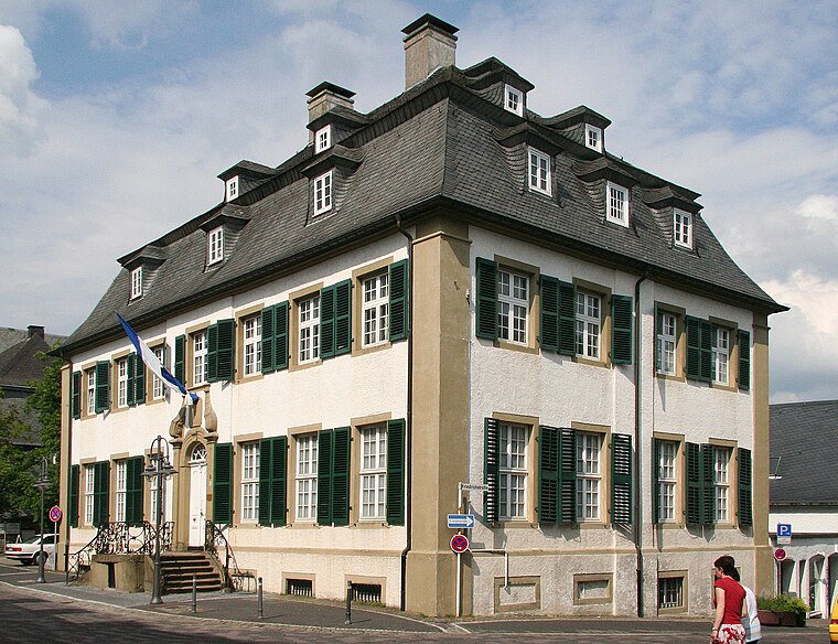 Haus Sauvigny is a historic building, which is situated 480 metres east of FF Brilon.
Petrusbrunnen
Fountain

Photo: SteveK, CC BY-SA 3.0.
Petrusbrunnen is a fountain, which is situated 470 metres southeast of FF Brilon.
Hövener House Museum
Museum

Photo: Wikimedia, CC BY-SA 3.0.
Hövener House Museum is situated 500 metres southeast of FF Brilon.
Places in the Area
Nearby places include Gudenhagen-Petersborn and Scharfenberg.
Gudenhagen-Petersborn
Village

Photo: Wikimedia, CC BY-SA 3.0.
Gudenhagen-Petersborn is a village, which is situated 3½ km south of FF Brilon.
Scharfenberg
Village

Photo: MBWesterwinter, CC BY-SA 4.0.
Scharfenberg is a village, which is situated 4 km northwest of FF Brilon.
Altenbüren
Village

Photo: Wikimedia, CC BY-SA 3.0.
Altenbüren is a village, which is situated 4 km west of FF Brilon.
FF Brilon
- Type: Land parcel
- Category: locality
- Location: Brilon, Hochsauerlandkreis, Arnsberg, North Rhine-Westphalia, Germany, Central Europe, Europe
- View on OpenStreetMap
Latitude
51.3975° or 51° 23′ 51″ northLongitude
8.56173° or 8° 33′ 42″ eastOpen location code
9F3C9HX6+2MOpenStreetMap ID
way 261550796OpenStreetMap feature
place=plot
This page is based on OpenStreetMap, Wikidata, and Wikimedia Commons.
We’d love your help improving our open data sources. Thank you for contributing.
Satellite Map
Discover FF Brilon from above in high-definition satellite imagery.
Notable Places Nearby
Highlights include DHL and HSK Performance Center.
Nearby Places
Explore places such as Mc Döner and Netto Marken-Discount.
North Rhine-Westphalia: Must-Visit Destinations
Delve into Cologne, Düsseldorf, Bonn, and Dortmund.
Curious Land Parcels to Discover
Uncover intriguing land parcels from every corner of the globe.
About Mapcarta. Data © OpenStreetMap contributors and available under the Open Database License". Text is available under the CC BY-SA 4.0 license, except for photos, directions, and the map. Photo: Daniel Schwen, CC BY-SA 2.5.