Long Wharf Maritime Center
Long Wharf Maritime Center is a building in Connecticut, New England which is located on Long Wharf Drive. Long Wharf Maritime Center is situated nearby to Pearl Harbor Memorial Park, as well as near the building Hotel Marcel.| Tap on a place to explore it |
Places of Interest Nearby
Highlights include New Haven Railway Station and Beinecke Rare Book and Manuscript Library.
New Haven Railway Station
Railway station
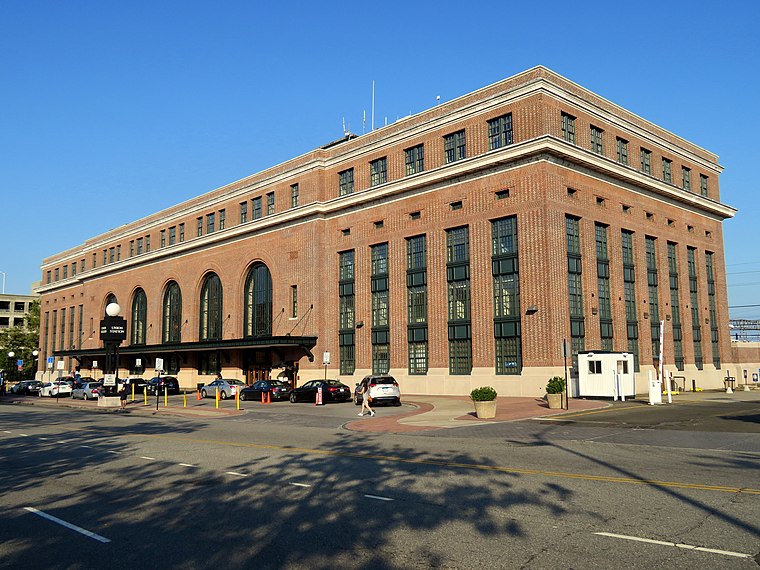
Photo: Pi.1415926535, CC BY-SA 3.0.
New Haven Union Station is the main railroad passenger station in New Haven, Connecticut. It is the third such station in the city of New Haven, preceded by both an 1848 built station in a different location, and an 1879 built station near the current station's location. New Haven Railway Station is situated 3,900 feet west of Long Wharf Maritime Center.
Beinecke Rare Book and Manuscript Library
Library
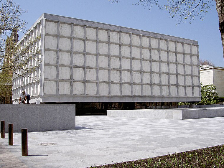
Photo: Wikimedia, Public domain.
The Beinecke Rare Book and Manuscript Library is the rare book library and literary archive of Yale University Library in New Haven, Connecticut. It is one of the largest buildings in the world dedicated to rare books and manuscripts and is one of the largest collections of such texts. Beinecke Rare Book and Manuscript Library is situated 1¼ miles northwest of Long Wharf Maritime Center.
Tomlinson Lift Bridge
Bridge

Photo: Pi.1415926535, CC BY-SA 4.0.
The Tomlinson Lift Bridge is a crossing of the Quinnipiac River in New Haven, Connecticut. The bridge forms a segment of U.S. Route 1. The Tomlinson Vertical Lift Bridge carries four lanes of traffic across New Haven Harbor and a single-track freight line owned by the Providence & Worcester Railroad that connects the waterfront with the Northeast Corridor line of Metro North and CSX. Tomlinson Lift Bridge is situated 2,000 feet east of Long Wharf Maritime Center.
Places in the Area
Nearby places include Wooster Square Historic District and Wooster Square.
Wooster Square Historic District
Neighborhood

Photo: Itub, CC BY-SA 3.0.
The Wooster Square Historic District encompasses much of the Wooster Square neighborhood of New Haven, Connecticut. Centered on a rectangular park named in honor of General David Wooster, the area was developed as a residential neighborhood beginning in the 1820s, and was by the 1840s a desirable area to live, with many high-quality Greek Revival homes.
Wooster Square
Neighborhood

Photo: Rhododendrites, CC BY-SA 4.0.
Wooster Square is a neighborhood in the city of New Haven, Connecticut, to the east of downtown. The name refers to a park square located between Greene Street, Wooster Place, Chapel Street and Academy Street in the center of the neighborhood.
Long Wharf
Neighborhood
Long Wharf is a waterfront district and neighborhood of the city of New Haven, Connecticut, United States. The neighborhood is a mixed-use district, with a combination of commercial, industrial, port, and recreation facilities.
Long Wharf Maritime Center
- Type: Building
- Address: 555 Long Wharf Drive, New Haven, CT 06519
- Location: Connecticut, New England, United States, North America
- View on OpenStreetMap
Latitude
41.2978° or 41° 17′ 52″ northLongitude
-72.91223° or 72° 54′ 44″ westInception
1985Levels
15Open location code
87H973XQ+44OpenStreetMap ID
way 269466662OpenStreetMap feature
building=yes
This page is based on OpenStreetMap, Wikidata, and Wikimedia Commons.
We’d love your help improving our open data sources. Thank you for contributing.
Satellite Map
Discover Long Wharf Maritime Center from above in high-definition satellite imagery.
Places with the Same Name
Discover other places named “Long Wharf Maritime Center”.
Notable Places Nearby
Highlights include Pearl Harbor Memorial Park and Hotel Marcel.
Nearby Places
Explore places such as Sports Haven and Connecticut Limo.
Connecticut: Must-Visit Destinations
Delve into Hartford, New Haven, Bridgeport, and Stamford.
Curious Buildings to Discover
Uncover intriguing buildings from every corner of the globe.
About Mapcarta. Data © OpenStreetMap contributors and available under the Open Database License". Text is available under the CC BY-SA 4.0 license, except for photos, directions, and the map. Photo: Wikimedia, CC0.