Bogenschützen Fürth e.V.
Bogenschützen Fürth e.V. is a sports venue in Fürth, Middle Franconia, Bavaria. Bogenschützen Fürth e.V. is situated nearby to the sports venue DJK 1920 Fürth, as well as near the church St. Nikolaus.| Tap on a place to explore it |
Places of Interest Nearby
Highlights include Fürth-Unterfürberg and Fürth Hardhöhe station.
Fürth-Unterfürberg
Railway stop

Photo: Wikimedia, CC BY-SA 3.0.
Fürth-Unterfürberg is a railway stop, which is situated 1 km northeast of Bogenschützen Fürth e.V..
Fürth Hardhöhe station
Metro station
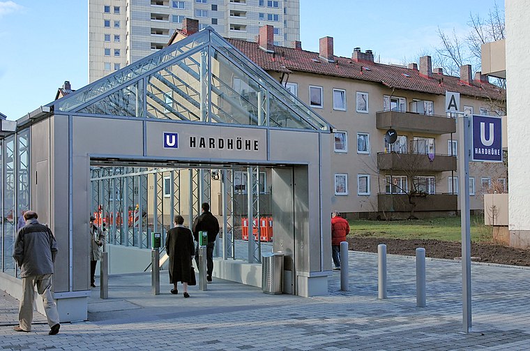
Photo: Wikimedia, CC BY-SA 3.0.
Fürth Hardhöhe station is a Nuremberg U-Bahn station located on line U1 in Fürth, and was opened on 8 December 2007. This station is the western terminus of line U1. Fürth Hardhöhe station is situated 1½ km northeast of Bogenschützen Fürth e.V..
Fürth Westvorstadt
Railway stop

Photo: Christian0911, CC BY-SA 3.0.
Fürth Westvorstadt is a railway stop, which is situated 1½ km east of Bogenschützen Fürth e.V..
Places in the Area
Nearby places include Unterfürberg and Dambach.


Bogenschützen Fürth e.V.
- Type: Sports venue
- Wheelchair access: limited
- Categories: archery, recreation area, and sports location
- Location: Fürth, Middle Franconia, Franconia, Bavaria, Germany, Central Europe, Europe
- View on OpenStreetMap
Latitude
49.46831° or 49° 28′ 6″ northLongitude
10.94966° or 10° 56′ 59″ eastOpen location code
8FXGFW9X+8VOpenStreetMap ID
way 287045362OpenStreetMap feature
leisure=sports_centreOpenStreetMap feature
sport=archeryOpenStreetMap attribute
wheelchair=limited
This page is based on OpenStreetMap, Wikidata, and Wikimedia Commons.
We’d love your help improving our open data sources. Thank you for contributing.
Satellite Map
Discover Bogenschützen Fürth e.V. from above in high-definition satellite imagery.
Notable Places Nearby
Highlights include DJK 1920 Fürth and St. Nikolaus.
Nearby Places
Explore places such as Oberfürb. Graf-Stauffenberg-Brücke and Graf-Stauffenberg-Brücke.
Middle Franconia: Must-Visit Destinations
Delve into Nuremberg, Erlangen, Ansbach, and Rothenburg ob der Tauber.
Curious Sports Venues to Discover
Uncover intriguing sports venues from every corner of the globe.
About Mapcarta. Data © OpenStreetMap contributors and available under the Open Database License". Text is available under the CC BY-SA 4.0 license, except for photos, directions, and the map. Photo: Wikimedia, CC BY-SA 3.0.