Pizzeria du territoire
Pizzeria du territoire is a building in La Chapelle-du-Noyer, Arrondissement of Châteaudun, Centre-Val de Loire. Pizzeria du territoire is situated nearby to the government office Communauté de Communes du Dunois, as well as near Direction Interdépartementale des Routes.| Tap on a place to explore it |
Places of Interest Nearby
Highlights include Château de Châteaudun and Couvent des Cordeliers de Châteaudun.
Château de Châteaudun
Castle
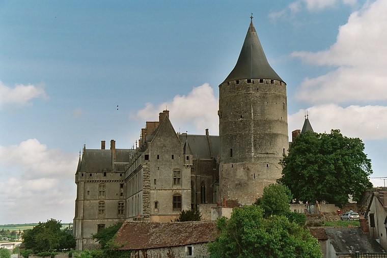
Photo: Calips, CC BY-SA 3.0.
The Château de Châteaudun is a castle located in the town of Châteaudun in the French department of Eure-et-Loir. Château de Châteaudun is situated 1¼ km northwest of Pizzeria du territoire.
Couvent des Cordeliers de Châteaudun
Historic building

Photo: Selbymay, CC BY-SA 3.0.
Couvent des Cordeliers de Châteaudun is a historic building, which is situated 690 metres north of Pizzeria du territoire.
Ancienne chapelle Notre-Dame du Champdé
Ruins

Photo: Selbymay, CC BY-SA 3.0.
Ancienne chapelle Notre-Dame du Champdé is a ruins, which is situated 710 metres north of Pizzeria du territoire.
Places in the Area
Nearby places include Châteaudun and Jallans.
Châteaudun
Town
Photo: Calips, CC BY-SA 3.0.
Châteaudun is a commune in the Eure-et-Loir department in northern France. It is a sub-prefecture of the department. It was the site of the Battle of Châteaudun during the Franco-Prussian War.
Jallans
Village

Photo: Blood Destructor, CC BY-SA 4.0.
Jallans is a commune in the Eure-et-Loir department in the Centre-Val de Loire region in northern France. Jallans is situated 3 km northeast of Pizzeria du territoire.
Marboué
Village

Photo: Selbymay, CC BY-SA 3.0.
Marboué is a commune in the Eure-et-Loir department in northern France. In June 1944, French resident of American citizenship, Virginia Roush, married to d'Albert Lake, was arrested near the village, she may have been tortured but never betrayed her fellow fighters. Marboué is situated 6 km north of Pizzeria du territoire.
Pizzeria du territoire
- Opening hours: 24/7
- Type: Building
- Location: La Chapelle-du-Noyer, Arrondissement of Châteaudun, Eure-et-Loir, Centre-Val de Loire, France, Europe
- View on OpenStreetMap
Latitude
48.06165° or 48° 3′ 42″ northLongitude
1.33309° or 1° 19′ 59″ eastOpen location code
8FW3386M+M6OpenStreetMap ID
way 287913810OpenStreetMap feature
amenity=vending_machineOpenStreetMap feature
building=service
This page is based on OpenStreetMap, Wikidata, and Wikimedia Commons.
We’d love your help improving our open data sources. Thank you for contributing.
Satellite Map
Discover Pizzeria du territoire from above in high-definition satellite imagery.
Notable Places Nearby
Highlights include Communauté de Communes du Dunois and Direction Interdépartementale des Routes.
Nearby Places
Explore places such as Wash X and Clean X.
Centre-Val de Loire: Must-Visit Destinations
Delve into Orléans, Tours, Chartres, and Bourges.
Curious Buildings to Discover
Uncover intriguing buildings from every corner of the globe.
About Mapcarta. Data © OpenStreetMap contributors and available under the Open Database License". Text is available under the CC BY-SA 4.0 license, except for photos, directions, and the map. Photo: Havang(nl), CC0.