Gemeindezentrum Sankt Theresien
Gemeindezentrum Sankt Theresien is a community center in Hamburg, Hamburg. Gemeindezentrum Sankt Theresien is situated nearby to the playground Spielplatz Paulsenplatz, as well as near the school Schule Bernstorffstraße.| Tap on a place to explore it |
Places of Interest Nearby
Highlights include Rote Flora and St John’s Church.
Rote Flora
Community center
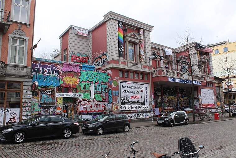
Photo: Hinnerk11, CC BY-SA 4.0.
The Rote Flora is a former theatre in the Sternschanze district of Hamburg, Germany. It has been squatted since November 1989 as a self-managed social centre. Rote Flora is situated 500 metres northeast of Gemeindezentrum Sankt Theresien.
St John’s Church
Church

Photo: Chris06, CC BY-SA 4.0.
St John’s Church is situated 220 metres northwest of Gemeindezentrum Sankt Theresien.
Millerntor-Stadion
Stadium

Photo: Arne mueseler, CC BY-SA 3.0 de.
Millerntor-Stadion is a multi-purpose stadium in the St. Pauli area of Hamburg, Germany. Best known as the home ground of football club FC St. Pauli, it is on the Heiligengeistfeld near the Reeperbahn, the red light district of Hamburg. Millerntor-Stadion is situated 1 km southeast of Gemeindezentrum Sankt Theresien.
Places in the Area
Nearby places include Altona-St. Pauli and Altona-Nord.
Altona-St. Pauli
Altona and St. Pauli are west of central Hamburg. Altona used to be an independent city and emerged as fisherman's village in the 16th century. It existed under Danish rule west of Hamburg, competing with it in trade and militarily.Altona-Nord
Suburb

Photo: Wikimedia, Public domain.
Altona-Nord located in the Altona borough in the city Hamburg, Germany, is one of 104 quarters of Hamburg. In 2023, the population was 26,807.
Altona-Altstadt
Suburb

Photo: Wmeinhart, CC BY-SA 3.0.
Altona-Altstadt is a quarter in Hamburg that belongs to the Altona borough. The quarter's boundaries are congruent with the historic center of what has been the city of Altona until 1937.
Gemeindezentrum Sankt Theresien
- Type: Community center
- Category: building
- Location: Hamburg, Hamburg, Freie und Hansestadt, Hamburg, Germany, Central Europe, Europe
- View on OpenStreetMap
Latitude
53.55879° or 53° 33′ 32″ northLongitude
9.95634° or 9° 57′ 23″ eastOpen location code
9F5FHX54+GGOpenStreetMap ID
way 291520351OpenStreetMap feature
amenity=community_centreOpenStreetMap feature
building=yes
This page is based on OpenStreetMap, Wikidata, and Wikimedia Commons.
We’d love your help improving our open data sources. Thank you for contributing.
Satellite Map
Discover Gemeindezentrum Sankt Theresien from above in high-definition satellite imagery.
Notable Places Nearby
Highlights include Sankt Theresien and Spielplatz Paulsenplatz.
Nearby Places
Explore places such as Schulhof and Struensee-Gymnasium - Standort Dohrnweg.
Hamburg: Must-Visit Destinations
Delve into Altona-St. Pauli, Neustadt-Altstadt, East Hamburg, and North Hamburg.
Curious Community Centers to Discover
Uncover intriguing community centers from every corner of the globe.
About Mapcarta. Data © OpenStreetMap contributors and available under the Open Database License". Text is available under the CC BY-SA 4.0 license, except for photos, directions, and the map. Photo: Joerg Moellenkamp, CC BY 2.0.