Wirtl’s Taubenturm
Wirtl’s Taubenturm is an amusement ride in Brühl, Rhein-Erft-Kreis, North Rhine-Westphalia. Wirtl’s Taubenturm is situated nearby to the carousel Die fröhliche Bienchenjagd, as well as near Würmling Express.| Tap on a place to explore it |
Places of Interest Nearby
Highlights include Phantasialand and Maus au Chocolat.
Phantasialand
Theme park

Photo: Wolkenkratzer, CC BY-SA 3.0.
Phantasialand is a theme park in Brühl, North Rhine-Westphalia, Germany that attracts approximately 2 million visitors annually. It was opened in 1967 by Gottlieb Löffelhardt and Richard Schmidt. Phantasialand is situated 140 metres east of Wirtl’s Taubenturm.
Maus au Chocolat
Amusement ride

Photo: Wim Strijbosch, CC BY 3.0.
Maus au Chocolat is an interactive dark ride that opened 9 June 2011 in Phantasialand, Germany. The ride is situated in the Berlin area of the park.
F.L.Y.
Roller coaster
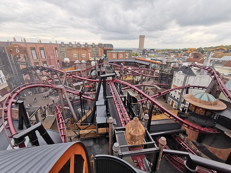
Photo: Sarion, CC BY-SA 4.0.
F.L.Y. is a flying launched roller coaster at Phantasialand in Brühl, Germany. The coaster is the sole attraction of the Rookburgh area, a highly themed immersive Steampunk city, which was soft opened in September 2020 following several years of development and construction.
Places in the Area
Nearby places include Pingsdorf and Walberberg.

Walberberg
Village

Photo: Superbass, CC BY-SA 4.0.
Walberberg is a village, which is situated 2½ km east of Wirtl’s Taubenturm.
Schwadorf
Village

Photo: S.Didam, CC BY-SA 3.0.
Schwadorf is a village, which is situated 2½ km east of Wirtl’s Taubenturm.
Wirtl’s Taubenturm
- Type: Amusement ride
- Wheelchair access: no
- Categories: tourism and tourist attraction
- Location: Brühl, Rhein-Erft-Kreis, Cologne District, Cologne Lowland, North Rhine-Westphalia, Germany, Central Europe, Europe
- View on OpenStreetMap
Latitude
50.80054° or 50° 48′ 2″ northLongitude
6.87896° or 6° 52′ 44″ eastOpen location code
9F28RV2H+6HOpenStreetMap ID
way 299665979OpenStreetMap feature
attraction=amusement_rideOpenStreetMap feature
tourism=attractionOpenStreetMap attribute
wheelchair=no
This page is based on OpenStreetMap, Wikidata, and Wikimedia Commons.
We’d love your help improving our open data sources. Thank you for contributing.
Satellite Map
Discover Wirtl’s Taubenturm from above in high-definition satellite imagery.
Notable Places Nearby
Highlights include Wirtl’s Taubenturm and Die fröhliche Bienchenjagd.
Nearby Places
Explore places such as Softeis Wuze-Tal and Schwan Snack.
Cologne Lowland: Must-Visit Destinations
Delve into Cologne, Bonn, Leverkusen, and Siegburg.
Curious Amusement Rides to Discover
Uncover intriguing amusement rides from every corner of the globe.
About Mapcarta. Data © OpenStreetMap contributors and available under the Open Database License". Text is available under the CC BY-SA 4.0 license, except for photos, directions, and the map. Photo: Davidh820, CC BY-SA 4.0.