Reiterhof Buchenhof
Reiterhof Buchenhof is a farm in Römhild, Hildburghausen, Thuringia which is located on Gut Buchenhof. Reiterhof Buchenhof is situated nearby to the hamlet Buchenhof (Gleichamberg), as well as near the peak Linzarzberg.| Tap on a place to explore it |
Places of Interest Nearby
Highlights include St. Nikolaus and Großer Gleichberg.
St. Nikolaus
Church

Photo: Störfix, CC BY-SA 3.0 de.
St. Nikolaus is a church, which is situated 1½ km southwest of Reiterhof Buchenhof.
Großer Gleichberg
Peak
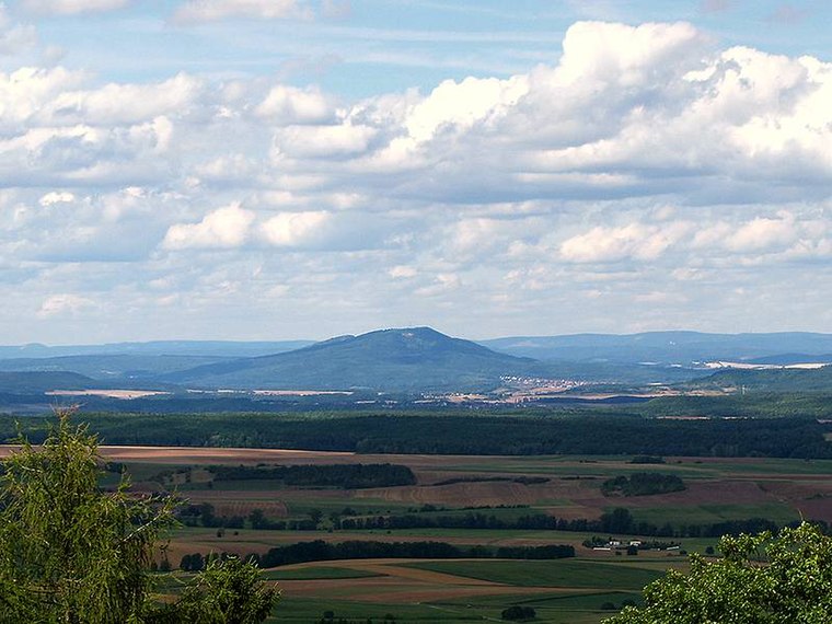
Photo: Kreuzschnabel, CC BY-SA 3.0.
At 679 m above sea level, the Großer Gleichberg is the higher of the two adjacent mountaintops known as the Gleichberge east of Römhild in the landscape of Grabfeld and the county of Hildburghausen in the German state of Thuringia.
St. Nikolaus
Church

Photo: Störfix, CC BY-SA 3.0 de.
St. Nikolaus is a church, which is situated 2 km southeast of Reiterhof Buchenhof.
Places in the Area
Nearby places include Buchenhof (Gleichamberg) and Gleichamberg.
Buchenhof (Gleichamberg)
Hamlet

Photo: Störfix, CC BY-SA 3.0 de.
Buchenhof (Gleichamberg) is a hamlet.
Gleichamberg
Village
Photo: Störfix, CC BY-SA 3.0 de.
Gleichamberg is a former municipality in the district of Hildburghausen in Thuringia. Since 31 December 2012, it is part of the town Römhild. Gleichamberg consisted of the following subdivisions:…

Reiterhof Buchenhof
- Type: Farm
- Address: Gut Buchenhof 11, Gleichamberg, Römhild, 98630
- Category: agriculture
- Location: Römhild, Hildburghausen, Thuringia, Germany, Central Europe, Europe
- View on OpenStreetMap
Latitude
50.37848° or 50° 22′ 43″ northLongitude
10.61639° or 10° 36′ 59″ eastOperator
Reiterhof BuchenhofOpen location code
9F2G9JH8+9HOpenStreetMap ID
way 303436657OpenStreetMap feature
landuse=farmyard
This page is based on OpenStreetMap, Wikidata, and Wikimedia Commons.
We’d love your help improving our open data sources. Thank you for contributing.
Satellite Map
Discover Reiterhof Buchenhof from above in high-definition satellite imagery.
Notable Places Nearby
Highlights include Linzarzberg and Speicher Roth I (verlandet).
Nearby Places
Explore places such as Kirschenleite and Seerangen.
Curious Farms to Discover
Uncover intriguing farms from every corner of the globe.
About Mapcarta. Data © OpenStreetMap contributors and available under the Open Database License". Text is available under the CC BY-SA 4.0 license, except for photos, directions, and the map. Photo: Taxiarchos228, FAL.