Escola Montserrat Vayreda
Escola Montserrat Vayreda is a school in Roses, Costa Brava, Catalonia which is located on Ronda de Dalt. Escola Montserrat Vayreda is situated nearby to the pitch Camps de futbol La Vinyassa, as well as near Estadi municipal Mas Oliva.| Tap on a place to explore it |
Places of Interest Nearby
Highlights include Santa Maria, Roses and Dolmen del Cap de l’Home.
Santa Maria, Roses
Monastery
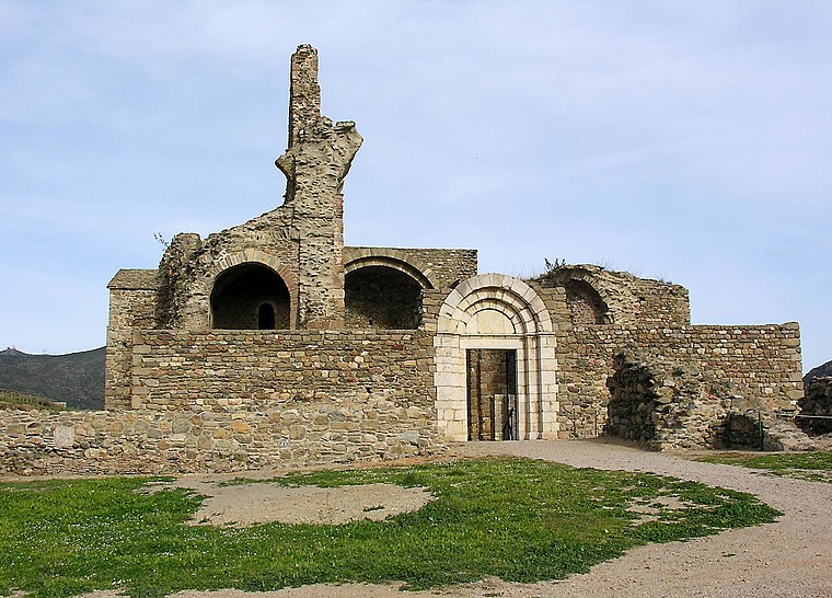 Santa Maria de Roses is a ruined Benedictine monastery in the municipality of Roses, Alt Empordà comarca, Catalonia, Spain. It is situated within the Ciutadella de Roses, a fortification in the Province of Girona. Santa Maria, Roses is situated 1 km southwest of Escola Montserrat Vayreda.
Dolmen del Cap de l’Home
Archaeological site

Photo: Argosgulto, CC BY-SA 3.0.
Dolmen del Cap de l’Home is an archaeological site, which is situated 1 km southeast of Escola Montserrat Vayreda.
Església de Santa Maria de Roses
Church

Photo: Gordito1869, CC BY 3.0.
Església de Santa Maria de Roses is a church, which is situated 1 km south of Escola Montserrat Vayreda.
Places in the Area
Nearby places include Canyelles, l’Almadrava i Santa Rosa de Puig-rom and Cap de Creus Natural Park.
Canyelles, l’Almadrava i Santa Rosa de Puig-rom
Neighborhood

Photo: Asarola, CC BY-SA 3.0 es.
Canyelles, l’Almadrava i Santa Rosa de Puig-rom is a neighborhood, which is situated 3 km southeast of Escola Montserrat Vayreda.
Cap de Creus Natural Park

Photo: Toni Pérez Padilla, CC BY-SA 4.0.
Cap de Creus Natural Park is in Costa Brava of Catalonia. Cap de Creus Natural Park is characterized by its rugged cliffs, hidden coves, and diverse ecosystems.
Cala Montjoi Holiday Village
Hamlet

Photo: Alan Mattingly, CC0.
Cala Montjoi Holiday Village is a hamlet, which is situated 4½ km southeast of Escola Montserrat Vayreda.
Escola Montserrat Vayreda
- Type: School
- Address: Ronda de Dalt 27, Roses, 17490
- Category: education
- Location: Roses, Costa Brava, Girona, Catalonia, Eastern Spain, Spain, Iberia, Europe
- View on OpenStreetMap
Latitude
42.27151° or 42° 16′ 17″ northLongitude
3.18179° or 3° 10′ 54″ eastNamed after
Montserrat VayredaOpen location code
8FJ575CJ+JPOpenStreetMap ID
way 304824105OpenStreetMap feature
amenity=schoolOpenStreetMap feature
landuse=education
This page is based on OpenStreetMap, Wikidata, and Wikimedia Commons.
We’d love your help improving our open data sources. Thank you for contributing.
Satellite Map
Discover Escola Montserrat Vayreda from above in high-definition satellite imagery.
Notable Places Nearby
Highlights include Camps de futbol La Vinyassa and Estadi municipal Mas Oliva.
Nearby Places
Explore places such as Roses and Piscina.
Costa Brava: Must-Visit Destinations
Delve into Figueres, Lloret de Mar, Cadaqués, and Tossa de Mar.
Curious Schools to Discover
Uncover intriguing schools from every corner of the globe.
About Mapcarta. Data © OpenStreetMap contributors and available under the Open Database License". Text is available under the CC BY-SA 4.0 license, except for photos, directions, and the map. Photo: Gordito1869, CC BY 3.0.