Zugleitstelle Düren Nord
Zugleitstelle Düren Nord is an industrial building in Düren, Cologne District, North Rhine-Westphalia. Zugleitstelle Düren Nord is situated nearby to the bridge Schoellerbrücke, as well as near the square Freiheitsplatz.| Tap on a place to explore it |
Places of Interest Nearby
Highlights include Düren station and St. Antonius.
Düren station
Railway station
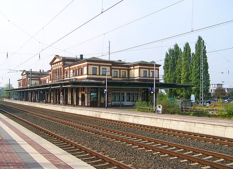
Photo: Zauberfee88, Public domain.
Düren station is located to the north of the centre of Düren and is the largest station in the city and the district of Düren. It is located at the intersection of the Cologne–Aachen high-speed line with the lines to Linnich, Heimbach and Euskirchen. Düren station is situated 590 metres southwest of Zugleitstelle Düren Nord.
St. Antonius
Church

Photo: Wikimedia, CC BY-SA 3.0.
St. Antonius is a church, which is situated 470 metres southeast of Zugleitstelle Düren Nord.
Stadtmuseum Düren
Museum

Photo: Braegel, CC BY-SA 3.0.
Stadtmuseum Düren is situated 610 metres south of Zugleitstelle Düren Nord.
Places in the Area
Nearby places include Grüngürtel and Düren.

Düren
Town

Photo: Wikimedia, CC BY-SA 4.0.
Düren is a town in North Rhine-Westphalia, Germany, between Aachen and Cologne, on the river Rur.
Arnoldsweiler
Village

Photo: Charlie1965nrw, CC BY-SA 3.0.
Arnoldsweiler is a village in Nordrhein-Westfalen, Germany. It is part of the town Düren, situated between Cologne and Aachen. Its population was 3,185 in 2017. Arnoldsweiler is situated 2½ km north of Zugleitstelle Düren Nord.
Zugleitstelle Düren Nord
- Type: Industrial building
- Categories: building and industry
- Location: Düren, Cologne District, North Rhine-Westphalia, Germany, Central Europe, Europe
- View on OpenStreetMap
Latitude
50.81453° or 50° 48′ 52″ northLongitude
6.4876° or 6° 29′ 15″ eastLevels
1Operator
Rurtalbahn GmbHOpen location code
9F28RF7Q+R2OpenStreetMap ID
way 307353599OpenStreetMap feature
building=industrialOpenStreetMap feature
railway=signal_box
This page is based on OpenStreetMap, Wikidata, and Wikimedia Commons.
We’d love your help improving our open data sources. Thank you for contributing.
Satellite Map
Discover Zugleitstelle Düren Nord from above in high-definition satellite imagery.
Notable Places Nearby
Highlights include Schoellerbrücke and Freiheitsplatz.
Nearby Places
Explore places such as Krafft Walzen and Arnoldsweilerstraße.
North Rhine-Westphalia: Must-Visit Destinations
Delve into Cologne, Düsseldorf, Bonn, and Dortmund.
Curious Industrial Buildings to Discover
Uncover intriguing industrial buildings from every corner of the globe.
About Mapcarta. Data © OpenStreetMap contributors and available under the Open Database License". Text is available under the CC BY-SA 4.0 license, except for photos, directions, and the map. Photo: Daniel Schwen, CC BY-SA 2.5.