Hotel Klausenhof Flüeli
Hotel Klausenhof Flüeli is a hotel in Sachseln, Obwalden which is located on Melchtalerstrasse. Hotel Klausenhof Flüeli is situated nearby to the church Obere Ranftkapelle, as well as near Lower Ranft Chapel.| Tap on a place to explore it |
Places of Interest Nearby
Highlights include Obere Ranftkapelle and Lower Ranft Chapel.
Obere Ranftkapelle
Church

Photo: Chrisaliv, CC BY-SA 4.0.
Obere Ranftkapelle is a church, which is situated 210 metres northeast of Hotel Klausenhof Flüeli.
Lower Ranft Chapel
Church

Photo: Roland Zumbuehl, CC BY-SA 4.0.
Lower Ranft Chapel is a church, which is situated 240 metres east of Hotel Klausenhof Flüeli.
Möslikapelle Kerns
Church
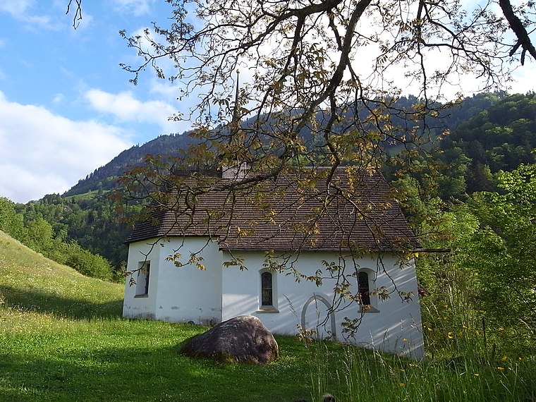
Photo: Rieunette, CC BY-SA 3.0.
Möslikapelle Kerns is a church, which is situated 380 metres southeast of Hotel Klausenhof Flüeli.
Places in the Area
Nearby places include Sachseln and Sarnen.
Sachseln
Village

Photo: Alpöhi, CC BY-SA 3.0.
Sachseln is a village and municipality in the canton of Obwalden in Switzerland. Besides the village of Sachseln, the municipality includes the hamlets of Edisried, Ewil and Flüeli-Ranft.
Sarnen
 Sarnen is the capital of the canton of Obwalden and sits on the shore of Lake Sarnen. Sarnen is an ideal starting point for numerous excursions by train, car or bike; a variety of sports can be practised here or in the immediate vicinity.
Kerns
Village

Photo: Roland Zumbuehl, CC BY 3.0.
Kerns is a village in the canton of Obwalden in Switzerland. Kerns is situated 3½ km north of Hotel Klausenhof Flüeli.
Hotel Klausenhof Flüeli
- Type: Hotel
- Address: Melchtalerstrasse 25, Flüeli-Ranft, 6073
- Categories: building, tourism, and accommodation
- Location: Sachseln, Obwalden, Canton of Obwalden, Switzerland, Central Europe, Europe
- View on OpenStreetMap
Latitude
46.86839° or 46° 52′ 6″ northLongitude
8.26924° or 8° 16′ 9″ eastOpen location code
8FRCV799+9MOpenStreetMap ID
way 309435526OpenStreetMap feature
building=yesOpenStreetMap feature
tourism=hotel
This page is based on OpenStreetMap, Wikidata, and Wikimedia Commons.
We’d love your help improving our open data sources. Thank you for contributing.
Satellite Map
Discover Hotel Klausenhof Flüeli from above in high-definition satellite imagery.
Notable Places Nearby
Highlights include Birth house of Nicholas of Flue and House of Nicholas of Flue.
Nearby Places
Explore places such as Unterholz and Vincentianum.
Switzerland: Must-Visit Destinations
Delve into Zurich, Berne, Geneva, and Basel.
Curious Places to Discover
Uncover intriguing places from every corner of the globe.
About Mapcarta. Data © OpenStreetMap contributors and available under the Open Database License". Text is available under the CC BY-SA 4.0 license, except for photos, directions, and the map. Photo: Simonizer, CC BY-SA 2.0 de.