Tököl VSK futballpálya
Tököl VSK futballpálya is a pitch in Pest County, Central Hungary. Tököl VSK futballpálya is situated nearby to the sports venue Tököli Sportcsarnok, as well as near the community center Művelődési Központ és Könyvtár.| Tap on a place to explore it |
Places of Interest Nearby
Highlights include Tokol Airport and Dunamenti Power Plant.
Tokol Airport
Aerodrome
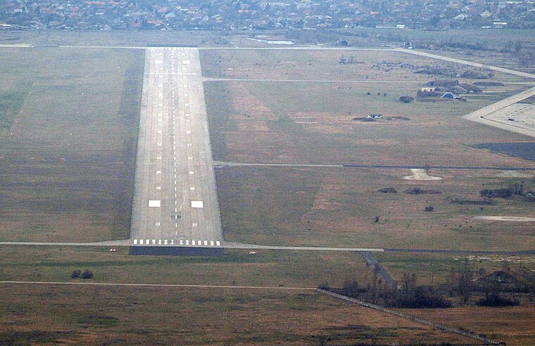 Tokol Airport is an aerodrome, which is situated 4 km north of Tököl VSK futballpálya.
Dunamenti Power Plant
Power station

Photo: DorysTS, CC BY-SA 4.0.
Dunamenti Power Plant is a power station, which is situated 3½ km northwest of Tököl VSK futballpálya.
Places in the Area
Nearby places include Szigethalom and Százhalombatta.
Szigethalom
Photo: Globetrotter19, CC BY-SA 3.0.
Szigethalom is a town in Pest county, Hungary. In reference to the 2022 census, the population of the town was at 17,644, with the female being at 9,060 while the male were at 8,584.
Százhalombatta

Photo: Globetrotter19, CC BY-SA 3.0.
Százhalombatta is a town of 18,000 people in Pest County. It is 27 km southwest of Budapest, on the west bank of the Danube, in the "corner of Mezőföld".
Szigetcsép
Village

Photo: Derzsi Elekes Andor, CC BY-SA 3.0.
Szigetcsép is a village in Pest county, Hungary. The Csepel Island has two villages, Lórév and Szigetscép, and the town of Ráckeve which is inhabited by Serbs as well as Hungarians and Germans. Szigetcsép is situated 5 km south of Tököl VSK futballpálya.
Tököl VSK futballpálya
- Type: Pitch
- Categories: recreation area, football, and sports location
- Location: Pest County, Central Hungary, Hungary, Central Europe, Europe
- View on OpenStreetMap
Latitude
47.31315° or 47° 18′ 47″ northLongitude
18.96315° or 18° 57′ 47″ eastOpen location code
8FVW8X77+77OpenStreetMap ID
way 319226156OpenStreetMap feature
leisure=pitchOpenStreetMap feature
sport=soccer
This page is based on OpenStreetMap, Wikidata, and Wikimedia Commons.
We’d love your help improving our open data sources. Thank you for contributing.
Satellite Map
Discover Tököl VSK futballpálya from above in high-definition satellite imagery.
Notable Places Nearby
Highlights include Tököli Sportcsarnok and Művelődési Központ és Könyvtár.
Nearby Places
Explore places such as Kabasi Pékség and Tököl, óvoda.
Pest County: Must-Visit Destinations
Delve into Érd, Cegléd, Gödöllő, and Budaörs.
Curious Pitches to Discover
Uncover intriguing pitches from every corner of the globe.
About Mapcarta. Data © OpenStreetMap contributors and available under the Open Database License". Text is available under the CC BY-SA 4.0 license, except for photos, directions, and the map. Photo: ucsendre, CC BY-SA 3.0.