Trafiktårn Øst
Trafiktårn Øst is an office building in Vesterbro-Kongens Enghave, Copenhagen municipality, Capital Region. Trafiktårn Øst is situated nearby to the government office Energistyrelsen, as well as near the park Nexus Landscape.| Tap on a place to explore it |
Photo: Dannebrog Spy, CC BY-SA 4.0.
- Type: Commercial building
- Description: officebuilding in Copenhagen
- Also known as: “Trafiktårnet” and “Trafiktårnet Øst”
Places of Interest Nearby
Highlights include Fisketorvet and Havneholmen station.
Fisketorvet
Shopping center

Photo: Susanne Nilsson, CC BY-SA 2.0.
Fisketorvet - Copenhagen Mall is a shopping centre located on Kalvebod Brygge waterfront in Copenhagen, Denmark. It is Denmark's third largest shopping center by size. Fisketorvet is situated 320 metres east of Trafiktårn Øst.
Havneholmen station
Metro station

Photo: ThatGuyOnline, CC BY 4.0.
Havneholmen station is an underground Copenhagen Metro station, located next to the eponymous street and development, in Copenhagen, Denmark. The station is on the M4 Line, between Copenhagen Central and Enghave Brygge. Havneholmen station is situated 230 metres southeast of Trafiktårn Øst.
Tivoli Gardens
Theme park
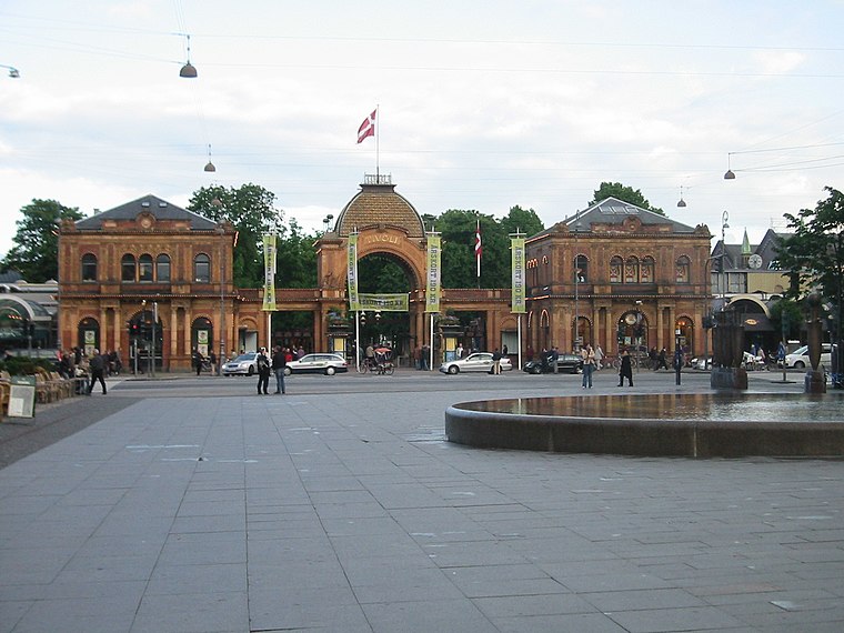
Photo: Elgaard, CC BY-SA 3.0.
Tivoli Gardens, also known simply as Tivoli, is an amusement park and pleasure garden in Copenhagen, Denmark. The park opened on 15 August 1843 and is the second-oldest operating amusement park in the world, after Dyrehavsbakken in nearby Klampenborg, also in Denmark. Tivoli Gardens is situated 1½ km northeast of Trafiktårn Øst.
Places in the Area
Nearby places include Vesterbro and Meatpacking District.
Vesterbro

Photo: Dannebrog Spy, CC BY-SA 3.0.
Vesterbro is just outside Copenhagen’s city centre )the Inner City or Indre By), making it a very attractive place to live. It includes the districts of Sydhavnen.
Meatpacking District
Suburb

Photo: Riemann, Public domain.
Kødbyen is a district of Vesterbro in Copenhagen, Denmark. It is situated between the railway lines going into Copenhagen Central Station and Sønder Boulevard.
Enghave Brygge
Neighborhood
Enghave Brygge is a waterfront area in the Southern Docklands of Copenhagen, Denmark. It is located between Vesterbro to the north and Frederiks Brygge to the south, and opposite Islands Brygge across the water.
Trafiktårn Øst
- Categories: office building, government office, building, and office
- Location: Vesterbro-Kongens Enghave, Copenhagen municipality, Capital Region, Denmark, Nordic countries, Europe
- View on OpenStreetMap
Latitude
55.66219° or 55° 39′ 44″ northLongitude
12.55631° or 12° 33′ 23″ eastLevels
9Height
41 metres (135 feet)Open location code
9F7JMH64+VGOpenStreetMap ID
way 321280172OpenStreetMap feature
building=commercialOpenStreetMap feature
office=governmentOpenStreetMap feature
railway=signal_boxWikidata ID
Q48215140
This page is based on OpenStreetMap, Wikidata, and Wikimedia Commons.
We’d love your help improving our open data sources. Thank you for contributing.
Satellite Map
Discover Trafiktårn Øst from above in high-definition satellite imagery.
In Other Languages
From Danish to Norwegian Bokmål—“Trafiktårn Øst” goes by many names.
- Danish: “Trafiktårn Øst”
- Norwegian Bokmål: “Trafiktårn Øst”
Notable Places Nearby
Highlights include Energistyrelsen and Nexus Landscape.
Nearby Places
Explore places such as Banedanmark Kantine and 40081 KPP OPP midlt. station.
Denmark: Must-Visit Destinations
Delve into Copenhagen, Aarhus, Odense, and Aalborg.
Curious Places to Discover
Uncover intriguing places from every corner of the globe.
About Mapcarta. Data © OpenStreetMap contributors and available under the Open Database License". Text is available under the CC BY-SA 4.0 license, except for photos, directions, and the map. Photo: Dannebrog Spy, CC BY-SA 4.0.