Top of Alpbachtal
Top of Alpbachtal is a building in Hart im Zillertal, Schwaz District, Tyrol. Top of Alpbachtal is situated nearby to the peak Wiedersberger Horn, as well as near the bridge Schibrücke/Pistenüberführung.| Tap on a place to explore it |
Places of Interest Nearby
Highlights include Wiedersberger Horn and Standkopf.
Wiedersberger Horn
Peak
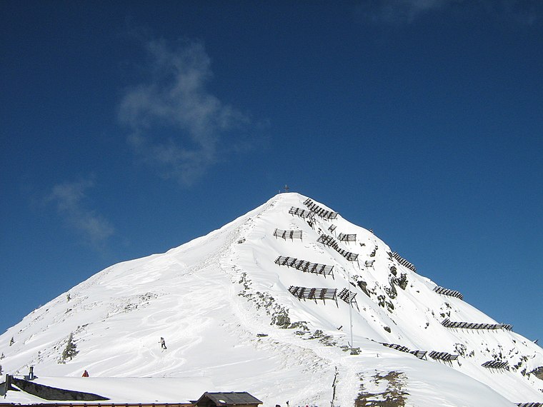
Photo: Hecki, Public domain.
The Wiedersberger Horn is a mountain in the Alpbachtal valley in Austria. Its summit is 2,127 m . The Wiedersberger Horn is accessible from the Alpbachtal via cableways and the mountainsides are used as a skiing area.
Standkopf
Peak

Photo: Svíčková, CC BY-SA 3.0.
Standkopf is a peak, which is situated 2½ km south of Top of Alpbachtal.
Hamberg
Peak

Photo: Braveheart, CC BY-SA 4.0.
Hamberg is a peak, which is situated 4 km south of Top of Alpbachtal.
Places in the Area
Nearby places include Alpbach and Fügen.
Alpbach

Photo: Karl Gruber, CC BY-SA 3.0.
Alpbach is a ski resort village in Northeast Tyrol. Alpbach has three valley stations that lead into the large ski area with 109 km of slopes. It is known for its unique wooden construction style.
Fügen

Photo: Böhringer, CC BY-SA 2.5.
Fügen is a village in the Schwaz district in Northeast Tyrol. This article also covers the villages of Finsing and Stumm. As a two-season tourist resort, Fügen benefits from the two ski areas — Hochfügen-Hochzillertal and Spieljoch — and the Zillertal thermal baths.
Schloss Matzen
Locality

Photo: Wolkenkratzer, CC BY-SA 4.0.
Schloss Matzen is a historic Austrian castle, located in the Tyrol near the branch of the Ziller Valley from the main Inn valley. Strategically located to control one of the major transalpine trade routes, the origins of the castle date from Roman times and it has a distinctive round tower thought to be of possible Roman derivation. Schloss Matzen is situated 8 km northwest of Top of Alpbachtal.
Top of Alpbachtal
- Type: Building
- Location: Hart im Zillertal, Schwaz District, Tyrol, Austria, Central Europe, Europe
- View on OpenStreetMap
Latitude
47.35882° or 47° 21′ 32″ northLongitude
11.92356° or 11° 55′ 25″ eastLevels
3Height
13 metres (43 feet)Open location code
8FVH9W5F+GCOpenStreetMap ID
way 322961639OpenStreetMap feature
building=yes
This page is based on OpenStreetMap, Wikidata, and Wikimedia Commons.
We’d love your help improving our open data sources. Thank you for contributing.
Satellite Map
Discover Top of Alpbachtal from above in high-definition satellite imagery.
Notable Places Nearby
Highlights include Top of Alpbachtal and Schibrücke/Pistenüberführung.
Nearby Places
Explore places such as Hornalm and Hornlift 2000.
Tyrol: Must-Visit Destinations
Delve into Innsbruck, Kufstein, Lienz, and Kitzbühel.
Curious Buildings to Discover
Uncover intriguing buildings from every corner of the globe.
About Mapcarta. Data © OpenStreetMap contributors and available under the Open Database License". Text is available under the CC BY-SA 4.0 license, except for photos, directions, and the map. Photo: Traveler100, CC BY-SA 3.0.