Straßenverwaltung Voitsberg
Straßenverwaltung Voitsberg is a building in Voitsberg, Styria which is located on Ruhmannstraße. Straßenverwaltung Voitsberg is situated nearby to the water park Erlebnisschwimmbad, as well as near the swimming pool Schwimmbecken.| Tap on a place to explore it |
Places of Interest Nearby
Highlights include Gustav-Adolf-Kirche Voitsberg and Filialkirche hl. Michael, Voitsberg.
Gustav-Adolf-Kirche Voitsberg
Church

Photo: Wikimedia, CC BY-SA 3.0 at.
Gustav-Adolf-Kirche Voitsberg is a church, which is situated 1 km northwest of Straßenverwaltung Voitsberg.
Filialkirche hl. Michael, Voitsberg
Church

Photo: Liuthalas, CC BY-SA 3.0 at.
Filialkirche hl. Michael, Voitsberg is a church, which is situated 1¼ km northwest of Straßenverwaltung Voitsberg.
Burg Obervoitsberg
Castle
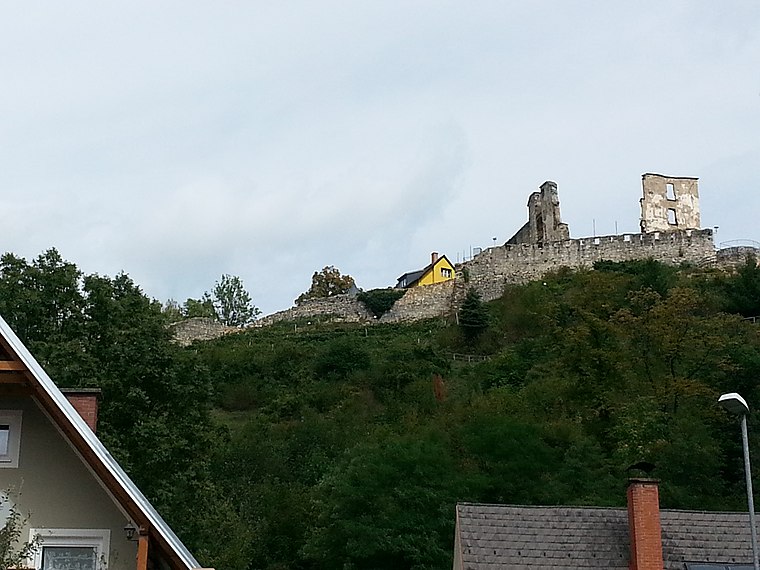
Photo: Liuthalas, CC BY-SA 3.0 at.
Burg Obervoitsberg is a castle in Voitsberg, Styria, Austria. Burg Obervoitsberg is situated 1¼ km north of Straßenverwaltung Voitsberg.
Places in the Area
Nearby places include Piberegg and Södingberg.
Piberegg
Village
Piberegg is a former municipality in the district of Voitsberg in the Austrian state of Styria. Since the 2015 Styria municipal structural reform, it is part of the municipality Bärnbach. Piberegg is situated 7 km northwest of Straßenverwaltung Voitsberg.
Södingberg
Village
Södingberg is a former municipality in the district of Voitsberg in the Austrian state of Styria. Since the 2015 Styria municipal structural reform, it is part of the municipality Geistthal-Södingberg. Södingberg is situated 8 km north of Straßenverwaltung Voitsberg.
Österreich
Hamlet

Photo: Liuthalas, CC BY-SA 4.0.
Österreich is a hamlet, which is situated 9 km east of Straßenverwaltung Voitsberg.
Straßenverwaltung Voitsberg
- Type: Building
- Address: Ruhmannstraße 3, Voitsberg, 8570
- Location: Voitsberg, Voitsberg District, Styria, Austria, Central Europe, Europe
- View on OpenStreetMap
Latitude
47.04027° or 47° 2′ 25″ northLongitude
15.15643° or 15° 9′ 23″ eastOpen location code
8FVQ25R4+4HOpenStreetMap ID
way 327733359OpenStreetMap feature
building=yes
This page is based on OpenStreetMap, Wikidata, and Wikimedia Commons.
We’d love your help improving our open data sources. Thank you for contributing.
Satellite Map
Discover Straßenverwaltung Voitsberg from above in high-definition satellite imagery.
Notable Places Nearby
Highlights include Erlebnisschwimmbad and Schwimmbecken.
Nearby Places
Explore places such as Straßenverwaltung Voitsberg and Erdbeerland.
Styria: Must-Visit Destinations
Delve into Graz, Leoben, Bruck an der Mur, and Kapfenberg.
Curious Buildings to Discover
Uncover intriguing buildings from every corner of the globe.
About Mapcarta. Data © OpenStreetMap contributors and available under the Open Database License". Text is available under the CC BY-SA 4.0 license, except for photos, directions, and the map. Photo: Kmarka, CC BY-SA 3.0.