Le PFC
Le PFC is a pitch in Sarlat-la-Canéda, Dordogne, Nouvelle-Aquitaine. Le PFC is situated nearby to the college Centre de formation pour les profesionnels de santé, as well as near Centre hospitalier de Sarlat.| Tap on a place to explore it |
Places of Interest Nearby
Highlights include Sarlat Cathedral and Maison de La Boétie.
Sarlat Cathedral
Church
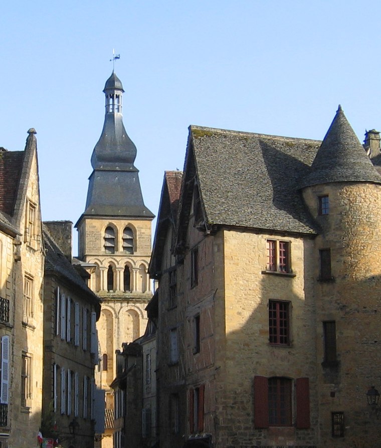
Photo: Wikimedia, Public domain.
Sarlat Cathedral is a Roman Catholic church and former cathedral located in Sarlat-la-Canéda, France. It is a national monument. The Diocese of Sarlat was established in 1317 with a number of bishoprics in the region in the aftermath of the suppression of the Albigensians. Sarlat Cathedral is situated 1¼ km south of Le PFC.
Maison de La Boétie
Historic building

Photo: Thesupermat, CC BY-SA 3.0.
Maison de La Boétie is a historic building, which is situated 1¼ km south of Le PFC.
Hôtel de ville de Sarlat-la-Canéda
Town hall
 Hôtel de ville de Sarlat-la-Canéda is a town hall, which is situated 1¼ km south of Le PFC.
Places in the Area
Nearby places include Sainte-Nathalène and Prats-de-Carlux.
Sainte-Nathalène
Village

Photo: Père Igor, CC BY-SA 3.0.
Sainte-Nathalène is a commune in the Dordogne department in Nouvelle-Aquitaine in southwestern France. Sainte-Nathalène is situated 5 km east of Le PFC.
Prats-de-Carlux
Village

Photo: Père Igor, CC BY-SA 4.0.
Prats-de-Carlux is a commune in the Dordogne department in Nouvelle-Aquitaine in southwestern France. Prats-de-Carlux is situated 7 km east of Le PFC.
Vitrac
Village

Photo: Manfred Heyde, CC BY-SA 3.0.
Vitrac is a commune in the Dordogne department in Nouvelle-Aquitaine in southwestern France. The Château de Montfort is situated in the commune. Vitrac is situated 8 km south of Le PFC.
Le PFC
- Type: Pitch
- Categories: recreation area and sports location
- Location: Sarlat-la-Canéda, Arrondissement of Sarlat-la-Canéda, Dordogne, Nouvelle-Aquitaine, France, Europe
- View on OpenStreetMap
Latitude
44.90023° or 44° 54′ 1″ northLongitude
1.22106° or 1° 13′ 16″ eastOpen location code
8FP3W62C+3COpenStreetMap ID
way 331536614OpenStreetMap feature
leisure=pitchOpenStreetMap feature
sport=multi
This page is based on OpenStreetMap, Wikidata, and Wikimedia Commons.
We’d love your help improving our open data sources. Thank you for contributing.
Satellite Map
Discover Le PFC from above in high-definition satellite imagery.
Notable Places Nearby
Highlights include Centre de formation pour les profesionnels de santé and Centre hospitalier de Sarlat.
Nearby Places
Explore places such as Le Pouget and Garrigou.
Dordogne: Must-Visit Destinations
Delve into Périgueux, Bergerac, Rocamadour, and Beynac-et-Cazenac.
Curious Pitches to Discover
Uncover intriguing pitches from every corner of the globe.
About Mapcarta. Data © OpenStreetMap contributors and available under the Open Database License". Text is available under the CC BY-SA 4.0 license, except for photos, directions, and the map. Photo: Shaundd, CC BY-SA 3.0.