Cincinnati Greyhound Station
Cincinnati Greyhound Station is a bus station in Cincinnati, Hamilton County, Ohio. Cincinnati Greyhound Station is situated nearby to Hard Rock Casino Cincinnati, as well as near the dog park Fido Field.| Tap on a place to explore it |
Places of Interest Nearby
Highlights include Hard Rock Casino Cincinnati and St. Paul Church.
Hard Rock Casino Cincinnati
Casino

Photo: JACK Digital Design, CC BY-SA 4.0.
Hard Rock Casino Cincinnati is a casino in Cincinnati, Ohio, owned by Vici Properties and operated by Hard Rock International. It opened in 2013. Hard Rock Casino Cincinnati is situated 680 feet west of Cincinnati Greyhound Station.
St. Paul Church
Church
 St. Paul Church is a former Roman Catholic church located on the southeastern corner of Twelfth and Spring Streets in Cincinnati, Ohio, United States, in the city's Pendleton neighborhood. St. Paul Church is situated 1,000 feet northwest of Cincinnati Greyhound Station.
Great American Ball Park
Stadium
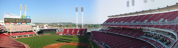
Photo: ekilby, CC BY-SA 2.0.
Great American Ball Park is a baseball stadium in Cincinnati, Ohio, United States. It is the ballpark of Major League Baseball's Cincinnati Reds, and opened on March 31, 2003, replacing Cinergy Field, the Reds' former ballpark from 1970 to 2002. Great American Ball Park is situated 4,000 feet south of Cincinnati Greyhound Station.
Places in the Area
Nearby places include Pendleton and Prospect Hill.
Pendleton
Suburb
Pendleton is one of the 52 neighborhoods of Cincinnati, Ohio. It is located within the city's urban basin. The population was 1,088 as of the 2020 census.
Prospect Hill
Neighborhood

Photo: Nyttend, Public domain.
Prospect Hill Historic District is located on a hillside outside of downtown Cincinnati, Ohio, United States. It is part of the Mount Auburn neighborhood of Cincinnati.
Mount Adams
Suburb

Photo: Wholtone, Public domain.
Mount Adams is one of the 52 neighborhoods of Cincinnati, Ohio. Located on a hill immediately east of downtown Cincinnati, it is south of Walnut Hills, southwest of East Walnut Hills, and west of the East End.
Cincinnati Greyhound Station
- Type: Bus station
- Categories: station and transportation
- Location: Cincinnati, Hamilton County, Greater Cincinnati, Ohio, Midwest, United States, North America
- View on OpenStreetMap
Latitude
39.10796° or 39° 6′ 29″ northLongitude
-84.50422° or 84° 30′ 15″ westLevels
1Operator
Greyhound LinesNetwork
Greyhound LinesOpen location code
86FQ4F5W+58OpenStreetMap ID
way 34230865OpenStreetMap feature
amenity=bus_stationOpenStreetMap feature
public_transport=station
This page is based on OpenStreetMap, Wikidata, and Wikimedia Commons.
We’d love your help improving our open data sources. Thank you for contributing.
Satellite Map
Discover Cincinnati Greyhound Station from above in high-definition satellite imagery.
Notable Places Nearby
Highlights include Hard Rock Casino Cincinnati and Fido Field.
Nearby Places
Explore places such as Greyhound and Bobby’s Burger Palace.
Hamilton County: Must-Visit Destinations
Delve into Cincinnati, Loveland, Downtown Cincinnati, and Sharonville.
Curious Bus Stations to Discover
Uncover intriguing bus stations from every corner of the globe.
About Mapcarta. Data © OpenStreetMap contributors and available under the Open Database License". Text is available under the CC BY-SA 4.0 license, except for photos, directions, and the map. Photo: Wikimedia, CC0.