Otorii (Nagoya)
Otorii (Nagoya) is a torii in Nakamura Ward, Nagoya, Aichi. Otorii (Nagoya) is situated nearby to the railway stop Nakamura Kōen Station, as well as near the bus station 中村公園.| Tap on a place to explore it |
Photo: Ray Larabie, CC BY 2.0.
- Type: Tourism
- Description: Torii in Nagoya, Aichi prefecture, Japan
- Also known as: “中村大鳥居”
Places of Interest Nearby
Highlights include Nakamura Kōen Station and Japanese Red Cross Nagoya Daiichi Hospital.
Nakamura Kōen Station
Railway stop
 There are currently 87 stations on the Nagoya Municipal Subway network with the first station being Sakae Station and Fushimi Station on the section on the Higashiyama Line, opened on November 15, 1957.
Japanese Red Cross Nagoya Daiichi Hospital
Hospital

Photo: Asturio Cantabrio, CC BY-SA 4.0.
Japanese Red Cross Nagoya Daiichi Hospital is situated 730 metres northeast of Otorii (Nagoya).
Nagoyashinakamura Library
Library

Photo: Asturio Cantabrio, CC BY-SA 4.0.
Nagoyashinakamura Library is situated 580 metres north of Otorii (Nagoya).
Places in the Area
Nearby places include Ōharu and Nishi Ward.
Ōharu
Town

Photo: Wikimedia, CC BY-SA 4.0.
Ōharu is a town located in Ama District, Aichi Prefecture, Japan. As of 1 October 2019, the town had an estimated population of 32,318 in 13,683 households, and a population density of 4,904 persons per km². Ōharu is situated 3 km west of Otorii (Nagoya).
Nishi Ward
Suburb

Photo: Nagono, CC BY-SA 3.0.
Nishi-ku is one of the 16 wards in the city of Nagoya in Aichi Prefecture, Japan. As of 1 October 2019, the ward has an estimated population of 150,480 and a population density of 8,393 persons per km2. The total area is 17.93 km2. Nishi Ward is situated 4 km northeast of Otorii (Nagoya).
Nagoya Castle
Locality
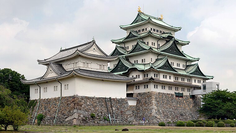
Photo: Base64, CC BY-SA 3.0.
Nagoya Castle is a Japanese castle located in Nagoya, Japan. Nagoya Castle was constructed by the Owari Domain in 1612 during the Edo period on the site of an earlier castle of the Oda clan in the Sengoku period. Nagoya Castle is situated 4½ km northeast of Otorii (Nagoya).
Otorii (Nagoya)
- Categories: torii and tourist attraction
- Location: Nakamura Ward, Nagoya, Aichi, Chubu, Japan, East Asia, Asia
- View on OpenStreetMap
Latitude
35.16865° or 35° 10′ 7″ northLongitude
136.85489° or 136° 51′ 18″ eastOpen location code
8Q7R5V93+FXOpenStreetMap ID
way 343919230OpenStreetMap feature
man_made=ceremonial_gateOpenStreetMap feature
tourism=gatewayWikidata ID
Q106678441
This page is based on OpenStreetMap, Wikidata, and Wikimedia Commons.
We’d love your help improving our open data sources. Thank you for contributing.
Satellite Map
Discover Otorii (Nagoya) from above in high-definition satellite imagery.
In Other Languages
“Otorii (Nagoya)” goes by many names.
- Japanese: “中村の大鳥居”
- Japanese: “大鳥居”
- Japanese: “赤鳥居”
Notable Places Nearby
Highlights include 中村公園 and 北林病院.
Nearby Places
Explore places such as 堀田理容 and 孝和堂.
Aichi: Must-Visit Destinations
Delve into Toyota, Toyohashi, Okazaki, and Ichinomiya.
Curious Places to Discover
Uncover intriguing places from every corner of the globe.
About Mapcarta. Data © OpenStreetMap contributors and available under the Open Database License". Text is available under the CC BY-SA 4.0 license, except for photos, directions, and the map. Photo: Ray Larabie, CC BY 2.0.