La Potée Fleurie
La Potée Fleurie is a garden center in Lachapelle-sous-Aubenas, Arrondissement of Largentière, Auvergne-Rhône-Alpes. La Potée Fleurie is situated nearby to the community center Salle Polyvalente, as well as near the village Saint-Sernin.| Tap on a place to explore it |
Places of Interest Nearby
Highlights include Église de l’Assomption de Lachapelle-sous-Aubenas and Église Saint-Saturnin de Saint-Sernin.
Église de l’Assomption de Lachapelle-sous-Aubenas
Church

Photo: Alainauzas, CC BY-SA 3.0.
Église de l’Assomption de Lachapelle-sous-Aubenas is a church, which is situated 1 km southwest of La Potée Fleurie.
Église Saint-Saturnin de Saint-Sernin
Church

Photo: Havang(nl), CC0.
Église Saint-Saturnin de Saint-Sernin is a church, which is situated 2 km east of La Potée Fleurie.
Aubenas Aerodrome
Aerodrome
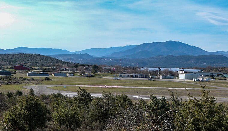
Photo: Kakoula10, CC BY-SA 4.0.
Aubenas Aerodrome or Aubenas Ardèche Méridionale Aerodrome is an airfield in Lanas, a commune in Ardèche, France. It has no scheduled airline service. It is home to the ULM makers Air Création. Aubenas Aerodrome is situated 3 km south of La Potée Fleurie.
Places in the Area
Nearby places include Saint-Sernin and Saint-Étienne-de-Fontbellon.
Saint-Sernin
Village
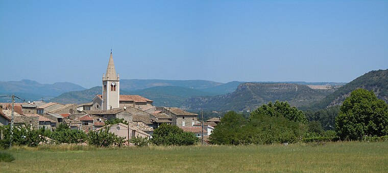
Photo: Patrice78500, CC BY-SA 3.0.
Saint-Sernin is a commune in the Ardèche department in southern France.
Saint-Étienne-de-Fontbellon
Village

Photo: 0ups, CC BY-SA 3.0.
Saint-Étienne-de-Fontbellon is a commune in the Ardèche department in southern France. Saint-Étienne-de-Fontbellon is situated 2½ km north of La Potée Fleurie.
Vogüé
Village

Photo: Wikimedia, Public domain.
Vogüé is a commune in the Ardèche department in southern France. It is a member of Les Plus Beaux Villages de France Association. Vogüé is situated 4½ km southeast of La Potée Fleurie.
La Potée Fleurie
- Type: Garden center
- Category: shop
- Location: Lachapelle-sous-Aubenas, Arrondissement of Largentière, Ardèche and Drôme, Auvergne-Rhône-Alpes, France, Europe
- View on OpenStreetMap
Latitude
44.57317° or 44° 34′ 23″ northLongitude
4.36961° or 4° 22′ 11″ eastOpen location code
8FP6H9F9+7ROpenStreetMap ID
way 345554145OpenStreetMap feature
shop=garden_centre
This page is based on OpenStreetMap, Wikidata, and Wikimedia Commons.
We’d love your help improving our open data sources. Thank you for contributing.
Satellite Map
Discover La Potée Fleurie from above in high-definition satellite imagery.
Notable Places Nearby
Highlights include Salle Polyvalente and Lachapelle-sous-Aubenas.
Nearby Places
Explore places such as Lachapelle Zone d’Activités and Lachapelle Zone d’Activités.
Ardèche and Drôme: Must-Visit Destinations
Delve into Die, Vallon-Pont-d’Arc, Buis-les-Baronnies, and Lagorce.
Curious Garden Centers to Discover
Uncover intriguing garden centers from every corner of the globe.
About Mapcarta. Data © OpenStreetMap contributors and available under the Open Database License". Text is available under the CC BY-SA 4.0 license, except for photos, directions, and the map. Photo: Perreal, CC BY-SA 3.0.