Centro de Saúde de Arruda dos Vinhos
Centro de Saúde de Arruda dos Vinhos is a hospital in Arruda dos Vinhos, Lisbon District which is located on Avenida Engenheiro Adriano Brito da Conceição. Centro de Saúde de Arruda dos Vinhos is situated nearby to the fire station Bombeiros Voluntários, as well as near the fountain Homenagem ao Bombeiro.| Tap on a place to explore it |
Places of Interest Nearby
Highlights include Câmara Municipal de Arruda dos Vinhos and Fort of Cego.
Câmara Municipal de Arruda dos Vinhos
Town hall

Photo: Vitor Oliveira, CC BY-SA 2.0.
Câmara Municipal de Arruda dos Vinhos is a town hall, which is situated 400 metres northeast of Centro de Saúde de Arruda dos Vinhos.
Fort of Cego
Protected area
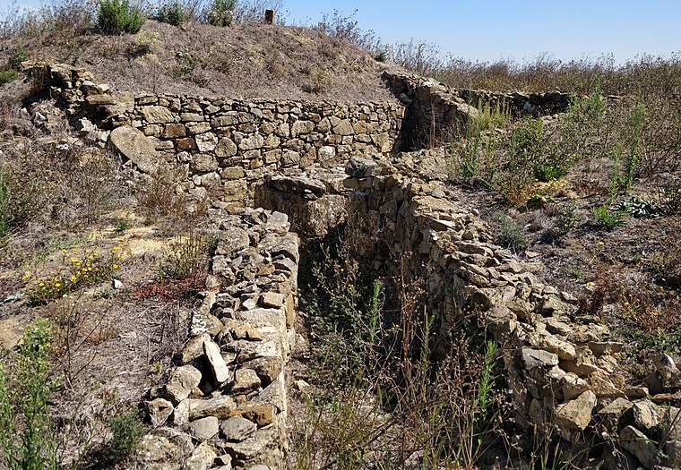
Photo: Roundtheworld, CC BY-SA 4.0.
The Fort of Cego is located in the municipality of Arruda dos Vinhos, in the Lisbon District of Portugal. It is also known as the Fort of Saint Sebastian. Fort of Cego is situated 1½ km south of Centro de Saúde de Arruda dos Vinhos.
Fort of Carvalha
Protected area

Photo: Roundtheworld, CC BY-SA 4.0.
The Fort of Carvalha is located in the parish of São Tiago dos Velhos, at the highest point of the municipality of Arruda dos Vinhos, in the Lisbon District of Portugal. Fort of Carvalha is situated 2 km southwest of Centro de Saúde de Arruda dos Vinhos.
Places in the Area
Nearby places include Cardosas and Arranhó.
Cardosas
Village
Cardosas is a civil parish in the municipality of Arruda dos Vinhos, Portugal. The population in 2011 was 836, in an area of 6.01 km2. Cardosas is situated 3½ km east of Centro de Saúde de Arruda dos Vinhos.
Arranhó
Town
Arranhó is a civil parish in the municipality of Arruda dos Vinhos, Portugal. The population in 2011 was 2,531, in an area of 21.47 km². Arranhó is situated 6 km southwest of Centro de Saúde de Arruda dos Vinhos.
Santo Quintino
Village

Photo: Vitor Oliveira, CC BY 2.0.
Santo Quintino is a village, which is situated 6 km northwest of Centro de Saúde de Arruda dos Vinhos.
Centro de Saúde de Arruda dos Vinhos
- Type: Hospital
- Address: Avenida Engenheiro Adriano Brito da Conceição 6, Arruda dos Vinhos, 2630-242
- Categories: health care, building, and clinic
- Location: Arruda dos Vinhos, Lisbon District, Portugal, Iberia, Europe
- View on OpenStreetMap
Latitude
38.98158° or 38° 58′ 54″ northLongitude
-9.08143° or 9° 4′ 53″ westOperator
ARSLVTOpen location code
8CCGXWJ9+JCOpenStreetMap ID
way 365707942OpenStreetMap feature
amenity=hospitalOpenStreetMap feature
building=yesOpenStreetMap feature
healthcare=centre
This page is based on OpenStreetMap, Wikidata, and Wikimedia Commons.
We’d love your help improving our open data sources. Thank you for contributing.
Satellite Map
Discover Centro de Saúde de Arruda dos Vinhos from above in high-definition satellite imagery.
Notable Places Nearby
Highlights include Bombeiros Voluntários and Homenagem ao Bombeiro.
Nearby Places
Explore places such as Telepizza and Av Eng Adriano Brito Conceição 1406.
Portugal: Must-Visit Destinations
Delve into Lisbon, Caldas da Rainha, Porto, and Coimbra.
Curious Hospitals to Discover
Uncover intriguing hospitals from every corner of the globe.
About Mapcarta. Data © OpenStreetMap contributors and available under the Open Database License". Text is available under the CC BY-SA 4.0 license, except for photos, directions, and the map. Photo: Vitor Oliveira, CC BY-SA 2.0.