Hullámtörő
Hullámtörő is a breakwater in Pest County, Central Hungary. Hullámtörő is situated nearby to the ruins Egykori téglagyár romjai, as well as near Dzsungel.| Tap on a place to explore it |
Places of Interest Nearby
Highlights include Tokol Airport and Érd minaret.
Tokol Airport
Aerodrome
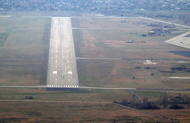 Tokol Airport is an aerodrome, which is situated 2½ km northeast of Hullámtörő.
Érd minaret
Mosque

Photo: Dominik.Tefert, Public domain.
The Érd minaret is an Ottoman era minaret tower situated in Érd near capital Budapest in Hungary. It is one of only three Ottoman era minarets still surviving in Hungary. Érd minaret is situated 3 km north of Hullámtörő.
Dunamenti Power Plant
Power station

Photo: DorysTS, CC BY-SA 4.0.
Dunamenti Power Plant is a power station, which is situated 2½ km southwest of Hullámtörő.
Places in the Area
Nearby places include Százhalombatta and Szigethalom.
Százhalombatta

Photo: Globetrotter19, CC BY-SA 3.0.
Százhalombatta is a town of 18,000 people in Pest County. It is 27 km southwest of Budapest, on the west bank of the Danube, in the "corner of Mezőföld".
Szigethalom
Photo: Globetrotter19, CC BY-SA 3.0.
Szigethalom is a town in Pest county, Hungary. In reference to the 2022 census, the population of the town was at 17,644, with the female being at 9,060 while the male were at 8,584.
Érd
Photo: Elekes Andor, CC BY-SA 4.0.
Érd is a suburb just southwest of Budapest in Pest County. It has the largest population in Pest County with about 67,000 inhabitants.
Hullámtörő
- Type: Breakwater
- Location: Pest County, Central Hungary, Hungary, Central Europe, Europe
- View on OpenStreetMap
Latitude
47.33629° or 47° 20′ 11″ northLongitude
18.94878° or 18° 56′ 56″ eastOpen location code
8FVW8WPX+GGOpenStreetMap ID
way 381225436OpenStreetMap feature
man_made=breakwater
This page is based on OpenStreetMap, Wikidata, and Wikimedia Commons.
We’d love your help improving our open data sources. Thank you for contributing.
Satellite Map
Discover Hullámtörő from above in high-definition satellite imagery.
Notable Places Nearby
Highlights include Egykori téglagyár romjai and Dzsungel.
Nearby Places
Explore places such as Százhalombatta, autóbusz-forduló and Százlábú tanösvény 6. tábla: földvár és téglagyári völgy.
Pest County: Must-Visit Destinations
Delve into Érd, Cegléd, Gödöllő, and Budaörs.
Curious Breakwaters to Discover
Uncover intriguing breakwaters from every corner of the globe.
About Mapcarta. Data © OpenStreetMap contributors and available under the Open Database License". Text is available under the CC BY-SA 4.0 license, except for photos, directions, and the map. Photo: ucsendre, CC BY-SA 3.0.