Martin-von-Tours-Schule
Martin-von-Tours-Schule is a school in Mülheim, Mülheim an der Ruhr, North Rhine-Westphalia. Martin-von-Tours-Schule is situated nearby to the town hall Technisches Rathaus, as well as near the metro station Von-Bock-Straße station.| Tap on a place to explore it |
Places of Interest Nearby
Highlights include Forum and Mülheim (Ruhr) Hauptbahnhof.
Forum
Shopping center

Photo: Wikimedia, CC BY-SA 3.0.
Forum is a shopping center, which is situated 290 metres northwest of Martin-von-Tours-Schule.
Mülheim (Ruhr) Hauptbahnhof
Railway station
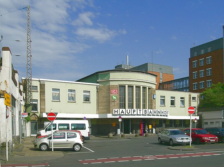
Photo: Docfeelgood3, Public domain.
Mülheim Hauptbahnhof is a railway station for the city of Mülheim in the German state of North Rhine-Westphalia. It was renamed as a Hauptbahnhof in 1974 at the time of the rebuilding of the Dortmund–Duisburg line as part of the establishment of the Rhine-Ruhr S-Bahn. Mülheim (Ruhr) Hauptbahnhof is situated 460 metres northwest of Martin-von-Tours-Schule.
Broich Castle

Photo: Wikimedia, Public domain.
Broich Castle is situated 1¼ km west of Martin-von-Tours-Schule.
Places in the Area
Nearby places include Siedlung Mausegatt and Styrum.

Styrum
Suburb

Photo: Docfeelgood3, Public domain.
Styrum is a suburb, which is situated 3½ km northwest of Martin-von-Tours-Schule.
Bedingrade
Suburb
Bedingrade is a northwestern borough of the city of Essen, Germany. It was incorporated into the city in 1915. Before it had been part of the Bürgermeisterei Borbeck. Bedingrade is situated 5 km northeast of Martin-von-Tours-Schule.
Martin-von-Tours-Schule
- Type: School
- Category: education
- Location: Mülheim, Mülheim an der Ruhr, Düsseldorf, Ruhr, North Rhine-Westphalia, Germany, Central Europe, Europe
- View on OpenStreetMap
Latitude
51.42786° or 51° 25′ 40″ northLongitude
6.89005° or 6° 53′ 24″ eastOpen location code
9F38CVHR+42OpenStreetMap ID
way 395264959OpenStreetMap feature
amenity=school
This page is based on OpenStreetMap, Wikidata, and Wikimedia Commons.
We’d love your help improving our open data sources. Thank you for contributing.
Satellite Map
Discover Martin-von-Tours-Schule from above in high-definition satellite imagery.
Notable Places Nearby
Highlights include Technisches Rathaus and all inclusive Fitness.
Nearby Places
Explore places such as Enisco and Haus HuMy.
Ruhr: Must-Visit Destinations
Delve into Dortmund, Essen, Duisburg, and Bochum.
Curious Schools to Discover
Uncover intriguing schools from every corner of the globe.
About Mapcarta. Data © OpenStreetMap contributors and available under the Open Database License". Text is available under the CC BY-SA 4.0 license, except for photos, directions, and the map. Photo: Omi´s Törtchen, CC BY-SA 2.0 de.