EDILIANS
EDILIANS is in La Salvetat-Saint-Gilles, Arrondissement of Toulouse, Occitanie. EDILIANS is situated nearby to Haras La Tuque, as well as near the village Pibrac.| Tap on a place to explore it |
Places of Interest Nearby
Highlights include Salvetat-Saint-Gilles Castle and Château de Pibrac.
Salvetat-Saint-Gilles Castle
Castle
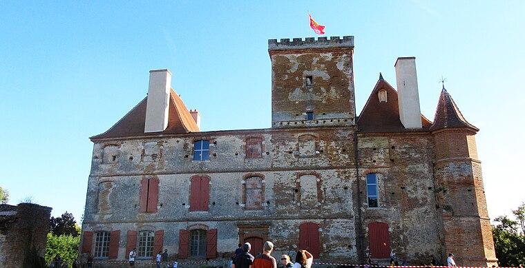
Photo: Agloforto, CC BY-SA 4.0.
Salvetat-Saint-Gilles Castle is situated 2 km south of EDILIANS.
Château de Pibrac
Castle

Photo: ErwChartes, CC BY-SA 3.0.
The Château de Pibrac is a converted 16th century castle in the commune of Pibrac in the Haute-Garonne département of France. It was rebuilt in 1540 to replace the old manor house. Château de Pibrac is situated 3 km north of EDILIANS.
Basilique Sainte-Germaine de Pibrac
Church

Photo: Archaeodontosaurus, CC BY-SA 4.0.
Basilique Sainte-Germaine de Pibrac is a church, which is situated 2½ km north of EDILIANS.
Places in the Area
Nearby places include Pibrac and Léguevin.
Pibrac
Village

Photo: Duch.seb, CC BY-SA 3.0.
Pibrac is a commune in the Haute-Garonne department in southwestern France, located 15 km west of Toulouse. It has recently grown thanks to the development of the aeroplane industry in the nearby town of Blagnac. Pibrac is situated 2½ km north of EDILIANS.
Léguevin
Village

Photo: Archaeodontosaurus, CC BY-SA 4.0.
Léguevin is a commune in the Haute-Garonne department in southwestern France. Léguevin is situated 3 km west of EDILIANS.
Brax
Village

Photo: Duch.seb, CC BY-SA 3.0.
Brax is a commune in the Haute-Garonne department in the Occitanie region. It is situated near the regional capital Toulouse near the Forêt de Bouconne. The village is part of the Toulouse Métropole. Brax is situated 3½ km northwest of EDILIANS.
EDILIANS
Latitude
43.59528° or 43° 35′ 43″ northLongitude
1.27424° or 1° 16′ 27″ eastOpen location code
8FM3H7WF+4MOpenStreetMap ID
way 400195814OpenStreetMap feature
landuse=industrial
This page is based on OpenStreetMap, Wikidata, and Wikimedia Commons.
We’d love your help improving our open data sources. Thank you for contributing.
Satellite Map
Discover EDILIANS from above in high-definition satellite imagery.
Places with the Same Name
Discover other places named “EDILIANS”.
Notable Places Nearby
Highlights include Haras La Tuque and CIS de Pibrac.
Nearby Places
Explore places such as Poste électrique de Léguevin and Poste source de Léguevin.
Haute-Garonne: Must-Visit Destinations
Delve into Toulouse, Boutx, Tarn, and Roquesérière.
Curious Places to Discover
Uncover intriguing places from every corner of the globe.
About Mapcarta. Data © OpenStreetMap contributors and available under the Open Database License". Text is available under the CC BY-SA 4.0 license, except for photos, directions, and the map. Photo: Kulmalukko, CC BY-SA 3.0.