Freiwillige Feuerwehr Astfeld
Freiwillige Feuerwehr Astfeld is a fire station in Langelsheim, Goslar, Lower Saxony which is located on Schulstraße. Freiwillige Feuerwehr Astfeld is situated nearby to Heimatstube Astfeld, as well as near the church Friedhofskapelle.| Tap on a place to explore it |
- Type: Fire station
- Address: Schulstraße 6, Langelsheim, 38685
- Roof shape: gabled
Places of Interest Nearby
Highlights include Grane Dam and Goslar station.
Grane Dam
Reservoir

Photo: Goseteufel, CC BY-SA 3.0.
The Grane Dam is a dam above the village of Astfeld/Herzog-Juliushütte in the borough of Langelsheim in the Lower Saxon part of the Harz mountains. Grane Dam is situated 3 km south of Freiwillige Feuerwehr Astfeld.
Goslar station
Railway station
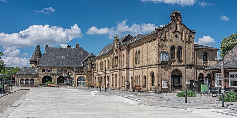 Goslar is a railway station located in Goslar, Germany. The station opened on 23 March 1866 and is located on the Vienenburg–Goslar railway, Hildesheim–Goslar railway and Neuekrug-Hahausen–Goslar railway. Goslar station is situated 3½ km southeast of Freiwillige Feuerwehr Astfeld.
Königsberg
Peak

Photo: Kassandro, CC BY-SA 3.0.
The 435 m high Königsberg is a hill in the Harz mountains in central Germany, southwest of Goslar between the Grane Reservoir and the Steinberg. On its summit are the ruins of an old tuberculosis convalescent home, later a children's home, the Königsberg Sanatorium. Königsberg is situated 3½ km southeast of Freiwillige Feuerwehr Astfeld.
Places in the Area
Nearby places include Herzog Juliushütte and Jerstedt.

Jerstedt
Village

Photo: Rabanus Flavus, CC0.
Jerstedt is a village, which is situated 3 km north of Freiwillige Feuerwehr Astfeld.
Baßgeige
Suburb

Photo: B.Thomas95, CC BY-SA 3.0.
Baßgeige is a suburb, which is situated 3 km east of Freiwillige Feuerwehr Astfeld.
Freiwillige Feuerwehr Astfeld
- Category: building
- Location: Langelsheim, Goslar, Lower Saxony, Germany, Central Europe, Europe
- View on OpenStreetMap
Latitude
51.92697° or 51° 55′ 37″ northLongitude
10.37296° or 10° 22′ 23″ eastOperator
Stadt LangelsheimOpen location code
9F3GW9GF+Q5OpenStreetMap ID
way 407757321OpenStreetMap feature
amenity=fire_stationOpenStreetMap feature
building=fire_stationOpenStreetMap attribute
roof-shape=gabled
This page is based on OpenStreetMap, Wikidata, and Wikimedia Commons.
We’d love your help improving our open data sources. Thank you for contributing.
Satellite Map
Discover Freiwillige Feuerwehr Astfeld from above in high-definition satellite imagery.
Notable Places Nearby
Highlights include Heimatstube Astfeld and Friedhofskapelle.
Nearby Places
Explore places such as Städt. Kita Astfeld and Schucke.
Lower Saxony: Must-Visit Destinations
Delve into Hanover, Göttingen, Brunswick, and Wolfsburg.
Curious Fire Stations to Discover
Uncover intriguing fire stations from every corner of the globe.
About Mapcarta. Data © OpenStreetMap contributors and available under the Open Database License". Text is available under the CC BY-SA 4.0 license, except for photos, directions, and the map. Photo: Danapit, CC BY-SA 3.0.