Pingo Doce
Pingo Doce is a supermarket in Benfica, Lisbon. Pingo Doce is situated nearby to the park Parque Silva Porto, as well as near the sports venue Vivafit Benfica.| Tap on a place to explore it |
Places of Interest Nearby
Highlights include Chafariz de Benfica and Church of Nossa Senhora do Amparo.
Chafariz de Benfica
Fountain

Photo: Menosketiago, CC BY 3.0.
Chafariz de Benfica is a fountain, which is situated 290 metres east of Pingo Doce.
Church of Nossa Senhora do Amparo
Church

Photo: Fimartinho, CC BY-SA 3.0.
Church of Nossa Senhora do Amparo is situated 250 metres northeast of Pingo Doce.
Estádio da Luz
Stadium
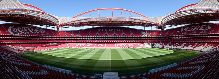
Photo: Massimo Catarinella, CC BY 3.0.
The Estádio da Luz, officially named Estádio do Sport Lisboa e Benfica, is a multi-purpose stadium located in Lisbon, Portugal. It is used mostly for association football matches, hosting the home games of Portuguese club Benfica, its owner. Estádio da Luz is situated 1½ km east of Pingo Doce.
Places in the Area
Nearby places include Buraca and Alfornelos.
Buraca
Suburb
Buraca is a former civil parish, located in the municipality of Amadora, Portugal. In 2013, the parish merged into the new parish of Águas Livres. As of the 2011 Census, it had a population of 15 892.

Carnide
Suburb
Carnide is a freguesia and typical quarter of Lisbon, the capital city of Portugal. Located in northern Lisbon, Carnide is north of São Domingos de Benfica and Benfica, east of Lumiar, and directly south of Lisbon's border with Odivelas.
Pingo Doce
- Type: Supermarket
- Postal code: 1500-339
- Categories: building, shop, and food
- Location: Benfica, Lisbon, Lisbon District, Portugal, Iberia, Europe
- View on OpenStreetMap
Latitude
38.74961° or 38° 44′ 59″ northLongitude
-9.20408° or 9° 12′ 15″ westHeight
18 metres (59 feet)Branch
Grão Vasco - BenficaBrand
Pingo DoceOpen location code
8CCGPQXW+R9OpenStreetMap ID
way 408028990OpenStreetMap feature
building=yesOpenStreetMap feature
shop=supermarket
This page is based on OpenStreetMap, Wikidata, and Wikimedia Commons.
We’d love your help improving our open data sources. Thank you for contributing.
Satellite Map
Discover Pingo Doce from above in high-definition satellite imagery.
Places with the Same Name
Discover other places named “Pingo Doce”.
Notable Places Nearby
Highlights include Parque Silva Porto and Vivafit Benfica.
Nearby Places
Explore places such as Domino’s and Externato Grão Vasco.
Lisbon: Must-Visit Destinations
Delve into Bairro Alto, Alfama, Baixa, and Belém.
Curious Supermarkets to Discover
Uncover intriguing supermarkets from every corner of the globe.
About Mapcarta. Data © OpenStreetMap contributors and available under the Open Database License". Text is available under the CC BY-SA 4.0 license, except for photos, directions, and the map. Photo: Alvesgaspar, CC BY-SA 3.0.