P2 (Parking Etudiants)
P2 (Parking Etudiants) is a parking area in Toulouse, Haute-Garonne, Occitanie. P2 (Parking Etudiants) is situated nearby to the university Amphi MDS2, as well as near La Présidence.| Tap on a place to explore it |
Places of Interest Nearby
Highlights include École nationale supérieure d’architecture de Toulouse and Château du Mirail.
École nationale supérieure d’architecture de Toulouse
University
The École nationale supérieure d'architecture de Toulouse is a French school of architecture, a unit of the University of Toulouse. École nationale supérieure d’architecture de Toulouse is situated 440 metres west of P2 (Parking Etudiants).
Château du Mirail
University
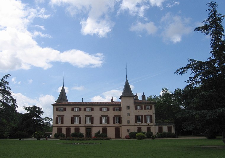
Photo: Wikimedia, Public domain.
The Château du Mirail is a castle in Toulouse. The Château du Mirail was commissioned by Guillaume de Mondran and built in 1680. The 52-hectare surrounding park was landscaped between 1700 and 1720. Château du Mirail is situated 490 metres southwest of P2 (Parking Etudiants).
Château de Reynerie
Castle

Photo: Mage31, Public domain.
Château de Reynerie is a castle, which is situated 1 km southwest of P2 (Parking Etudiants).
Places in the Area
Nearby places include Le Mirail and Toulouse Bagatelle.
Le Mirail
Suburb

Photo: Traumrune, CC BY-SA 3.0.
Le Mirail is a district in Toulouse, France. It was an urban expansion project proposed by the then-mayor Louis Bazerque in 1958, to combat the increasing population, and resulting housing shortage.


P2 (Parking Etudiants)
- Type: Parking area
- Parking: street-side
- Category: transportation
- Location: Toulouse, Arrondissement of Toulouse, Haute-Garonne, Occitanie, France, Europe
- View on OpenStreetMap
Latitude
43.5796° or 43° 34′ 47″ northLongitude
1.4031° or 1° 24′ 11″ eastOpen location code
8FM3HCH3+R6OpenStreetMap ID
way 412449627OpenStreetMap feature
amenity=parkingOpenStreetMap attribute
parking=street_side
This page is based on OpenStreetMap, Wikidata, and Wikimedia Commons.
We’d love your help improving our open data sources. Thank you for contributing.
Satellite Map
Discover P2 (Parking Etudiants) from above in high-definition satellite imagery.
Notable Places Nearby
Highlights include Amphi MDS2 and La Présidence.
Nearby Places
Explore places such as Parking Etudiants and Humanité.
Haute-Garonne: Must-Visit Destinations
Delve into Boutx, Tarn, Roquesérière, and Pechbonnieu.
Curious Parking Areas to Discover
Uncover intriguing parking areas from every corner of the globe.
About Mapcarta. Data © OpenStreetMap contributors and available under the Open Database License". Text is available under the CC BY-SA 4.0 license, except for photos, directions, and the map. Photo: PierreSelim, CC BY 3.0.