Hans-Adlhoch Turnhalle
Hans-Adlhoch Turnhalle is a sports venue in Augsburg, Bavarian Swabia, Bavaria. Hans-Adlhoch Turnhalle is situated nearby to the school building Hans-Adlhoch-Schule, as well as near the post office DHL.| Tap on a place to explore it |
Places of Interest Nearby
Highlights include Rosenaustadion and Hans-Adlhoch-Schule.
Rosenaustadion
Stadium
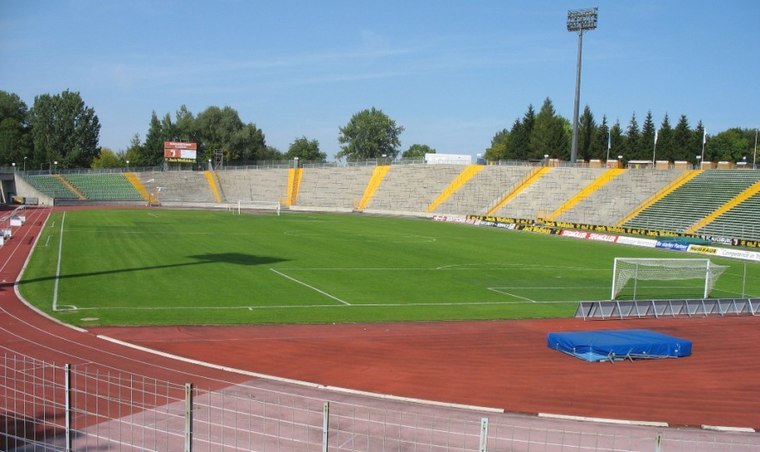
Photo: Wikimedia, CC BY-SA 3.0.
Rosenaustadion is a multi-purpose stadium in Augsburg, Bavaria, Germany. Built in 1951, it is a heritage listed monument and was the largest stadium in Augsburg for 58 years until 2009 when the Augsburg Arena was opened. Rosenaustadion is situated 460 metres southeast of Hans-Adlhoch Turnhalle.
Hans-Adlhoch-Schule
School building

Photo: Living-wreck, CC BY-SA 4.0.
Hans-Adlhoch-Schule is a school building.
St. Paul
Church

Photo: Jkü, CC BY-SA 3.0.
St. Paul is a church, which is situated 560 metres north of Hans-Adlhoch Turnhalle.
Places in the Area
Nearby places include Pfersee and Augsburg-Göggingen.
Pfersee
Suburb
Pfersee is a part of the city of Augsburg, Bavaria with some 25.000 inhabitants on the western shore of river Wertach. In 1911 Pfersee was incorporated to Augsburg.
Augsburg-Göggingen
Suburb
 Göggingen is one of the 17 Planungsräume of Augsburg, Bavaria, Germany. The Planungsraum is made up of three Stadtbezirke, the 37th, 38th and 40th Stadtbezirke, which are named Göggingen-Nordwest, Göggingen-Nordost and Göggingen-Süd, respectively.
Augsburg-Bismarckviertel
Neighborhood

Photo: Wikimedia, CC BY-SA 3.0.
Augsburg-Bismarckviertel is a neighborhood.
Hans-Adlhoch Turnhalle
- Type: Sports venue
- Categories: building, recreation area, school building, and sports location
- Location: Augsburg, Bavarian Swabia, Bavaria, Germany, Central Europe, Europe
- View on OpenStreetMap
Latitude
48.35735° or 48° 21′ 27″ northLongitude
10.87078° or 10° 52′ 15″ eastLevels
1Open location code
8FWG9V4C+W8OpenStreetMap ID
way 41276774OpenStreetMap feature
building=schoolOpenStreetMap feature
leisure=sports_centreOpenStreetMap feature
sport=multi
This page is based on OpenStreetMap, Wikidata, and Wikimedia Commons.
We’d love your help improving our open data sources. Thank you for contributing.
Satellite Map
Discover Hans-Adlhoch Turnhalle from above in high-definition satellite imagery.
Notable Places Nearby
Highlights include DHL and 11er Biergarten.
Nearby Places
Explore places such as Parkplatz Hans-Adlhoch Turnhalle and Hans-Adlhoch-Schule.
Bavarian Swabia: Must-Visit Destinations
Delve into Memmingen, Kempten, Füssen, and Lindau.
Curious Sports Venues to Discover
Uncover intriguing sports venues from every corner of the globe.
About Mapcarta. Data © OpenStreetMap contributors and available under the Open Database License". Text is available under the CC BY-SA 4.0 license, except for photos, directions, and the map. Photo: Tilman2007, CC BY-SA 3.0.