Natursteinwerk Amelgatzen
Natursteinwerk Amelgatzen is a building in Emmerthal, Hameln-Pyrmont, Lower Saxony which is located on Amelgatzer Straße. Natursteinwerk Amelgatzen is situated nearby to the cemetery Friedhof Amelgatzen, as well as near the fire station Freiwillige Feuerwehr Amelgatzen.| Tap on a place to explore it |
Places of Interest Nearby
Highlights include Schloss Hämelschenburg.
Schloss Hämelschenburg
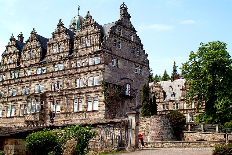
Photo: Bernd Schwabe in Hannover, CC BY-SA 3.0.
Schloss Hämelschenburg is situated 2 km north of Natursteinwerk Amelgatzen.
Places in the Area
Nearby places include Amelgatzen and Grohnde.

Grohnde
Village

Photo: Losch, CC BY-SA 3.0.
Grohnde is a village, which is situated 6 km east of Natursteinwerk Amelgatzen.
Tündern
Village

Photo: Thomas Fietzek, CC BY-SA 3.0.
Tündern is a village, which is situated 7 km northeast of Natursteinwerk Amelgatzen.
Natursteinwerk Amelgatzen
- Type: Building
- Address: Amelgatzer Straße 24, Emmerthal, 31860
- Location: Emmerthal, Hameln-Pyrmont, Lower Saxony, Germany, Central Europe, Europe
- View on OpenStreetMap
Latitude
52.01° or 52° 0′ 36″ northLongitude
9.33803° or 9° 20′ 17″ eastOpen location code
9F4F286Q+26OpenStreetMap ID
way 432958303OpenStreetMap feature
building=yes
This page is based on OpenStreetMap, Wikidata, and Wikimedia Commons.
We’d love your help improving our open data sources. Thank you for contributing.
Satellite Map
Discover Natursteinwerk Amelgatzen from above in high-definition satellite imagery.
Notable Places Nearby
Highlights include Friedhof Amelgatzen and Freiwillige Feuerwehr Amelgatzen.
Nearby Places
Explore places such as Strandkorb Manufaktur and Grundschule Amelgatzen.
Lower Saxony: Must-Visit Destinations
Delve into Hanover, Göttingen, Brunswick, and Wolfsburg.
Curious Buildings to Discover
Uncover intriguing buildings from every corner of the globe.
About Mapcarta. Data © OpenStreetMap contributors and available under the Open Database License". Text is available under the CC BY-SA 4.0 license, except for photos, directions, and the map. Photo: Danapit, CC BY-SA 3.0.