Les Moniques
Les Moniques is a subdivision in Toulon, Var, Provence-Alpes-Côte d’Azur.| Tap on a place to explore it |
Places of Interest
Highlights include Toulon Railway Station and Mont Faron.
Toulon Railway Station
Railway station

Photo: Wikimedia, Public domain.
Toulon station is a French railway station serving the city Toulon, Var department, southeastern France. It is situated on the Marseille–Ventimiglia railway.
Mont Faron
Peak
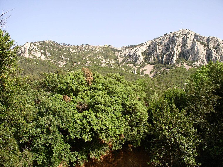
Photo: Wikimedia, CC BY-SA 1.0.
Mont Faron is a mountain overlooking the city and roadstead of Toulon, France. It is 584m high. At its peak is a memorial dedicated to the 1944 Allied landings in Provence, and to the liberation of Toulon.
Stade Mayol
Stadium

Photo: Johnjohn83var, Public domain.
The Stade Mayol is a multi-purpose stadium in Toulon, France. It is currently used mostly for rugby union matches and is the home stadium of RC Toulonnais.
Places in the Area
Nearby places include Sanary-sur-Mer and La Seyne-sur-Mer.
Sanary-sur-Mer

Photo: Marianne Casamance, CC BY-SA 3.0.
Sanary-sur-Mer, popularly known as Sanary, is a commune in the Var department in the Provence-Alpes-Côte d'Azur region, Southeastern France. Sanary-sur-Mer is located in coastal Provence on the Mediterranean Sea, 13 km west of Toulon and 49 km southeast of Marseille.
La Seyne-sur-Mer
Town

Photo: Mfe, CC BY-SA 3.0.
La Seyne-sur-Mer, or simply La Seyne, is a commune in the Var department in the Provence-Alpes-Côte d'Azur region in Southeastern France. La Seyne-sur-Mer, which is part of the agglomeration of Toulon, is situated adjacent to the west of the city.
La Valette-du-Var
Town

Photo: Esby, CC BY-SA 3.0.
La Valette-du-Var is a commune in the Var department in the Provence-Alpes-Côte d'Azur region in Southeastern France.
Les Moniques
- Type: Subdivision
- Categories: residential area and locality
- Location: Toulon, Arrondissement of Toulon, Var, Provence-Alpes-Côte d’Azur, France, Europe
- View on OpenStreetMap
Latitude
43.1491° or 43° 8′ 57″ northLongitude
5.9156° or 5° 54′ 56″ eastOpen location code
8FM74WX8+M6OpenStreetMap ID
way 436656983OpenStreetMap feature
landuse=residentialOpenStreetMap feature
place=subdivision
This page is based on OpenStreetMap, Wikidata, and Wikimedia Commons.
We’d love your help improving our open data sources. Thank you for contributing.
Satellite Map
Discover Les Moniques from above in high-definition satellite imagery.
Localities in the Area
Explore places such as Saint-André and Poudrière Saint-André.
Notable Places Nearby
Highlights include Grotte de l’Ubac and Faron citerne.
Var: Must-Visit Destinations
Delve into Saint-Tropez, Hyères, Fréjus, and Saint-Raphaël.
Curious Subdivisions to Discover
Uncover intriguing subdivisions from every corner of the globe.
About Mapcarta. Data © OpenStreetMap contributors and available under the Open Database License". Text is available under the CC BY-SA 4.0 license, except for photos, directions, and the map. Photo: yves Tennevin, CC BY 2.0.