Gymnázium a Střední Odborná Škola
Gymnázium a Střední Odborná Škola is a college in Jilemnice, Semily District, Liberec Region. Gymnázium a Střední Odborná Škola is situated nearby to Church of Saint Lawrence in Jilemnice, as well as near the library Městská knihovna Jaroslava Havlíčka.| Tap on a place to explore it |
Places of Interest Nearby
Highlights include Jilemnice Castle and Krkonošské muzeum Jilemnice.
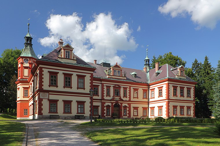
Krkonošské muzeum Jilemnice
Museum

Photo: Jiří Erben, CC BY-SA 3.0.
Krkonošské muzeum Jilemnice is a museum.

Places in the Area
Nearby places include Jilemnice and Hrabačov.
Jilemnice
Town

Photo: Frydolin, CC BY-SA 3.0.
Jilemnice is a town in Semily District in the Liberec Region of the Czech Republic. It has about 5,400 inhabitants. The historic town centre is well preserved and is protected as an urban monument zone.

Dolní Štěpanice
Village

Photo: VitVit, CC BY-SA 4.0.
Dolní Štěpanice is a village, which is situated 3 km northeast of Gymnázium a Střední Odborná Škola.
Gymnázium a Střední Odborná Škola
- Type: College
- Categories: building and education
- Location: Jilemnice, Semily District, Liberec Region, Czech Republic, Central Europe, Europe
- View on OpenStreetMap
Latitude
50.6098° or 50° 36′ 35″ northLongitude
15.50528° or 15° 30′ 19″ eastOpen location code
9F2QJG54+W4OpenStreetMap ID
way 44510233OpenStreetMap feature
amenity=collegeOpenStreetMap feature
building=yes
This page is based on OpenStreetMap, Wikidata, and Wikimedia Commons.
We’d love your help improving our open data sources. Thank you for contributing.
Satellite Map
Discover Gymnázium a Střední Odborná Škola from above in high-definition satellite imagery.
Notable Places Nearby
Highlights include Městská knihovna Jaroslava Havlíčka and Masarykovo náměstí.
Nearby Places
Explore places such as Geolog František Pošepný and Kavárna U Zámku.
Czech Republic: Must-Visit Destinations
Delve into Prague, Brno, Pilsen, and Ostrava.
Curious Colleges to Discover
Uncover intriguing colleges from every corner of the globe.
About Mapcarta. Data © OpenStreetMap contributors and available under the Open Database License". Text is available under the CC BY-SA 4.0 license, except for photos, directions, and the map. Photo: john mcsporran, CC BY 2.0.