Diesel Fuel Storage Containment Ring
Diesel Fuel Storage Containment Ring is a building in City of Scranton, Lackawanna County, Pennsylvania. Diesel Fuel Storage Containment Ring is situated nearby to the ruins Mine Storage Building foundation, as well as near 1902 Roundhouse & Technology Museum.| Tap on a place to explore it |
Places of Interest Nearby
Highlights include The Marketplace at Steamtown and Electric City Trolley Museum.
The Marketplace at Steamtown
Shopping center

Photo: Daniel Case, CC BY-SA 3.0.
The Marketplace at Steamtown is a shopping mall in Scranton, Pennsylvania. United States. It was conceived in the mid-1980s as the keystone of downtown revitalization, though the project was not completed until 1993. The Marketplace at Steamtown is situated 550 feet northeast of Diesel Fuel Storage Containment Ring.
Electric City Trolley Museum
Museum
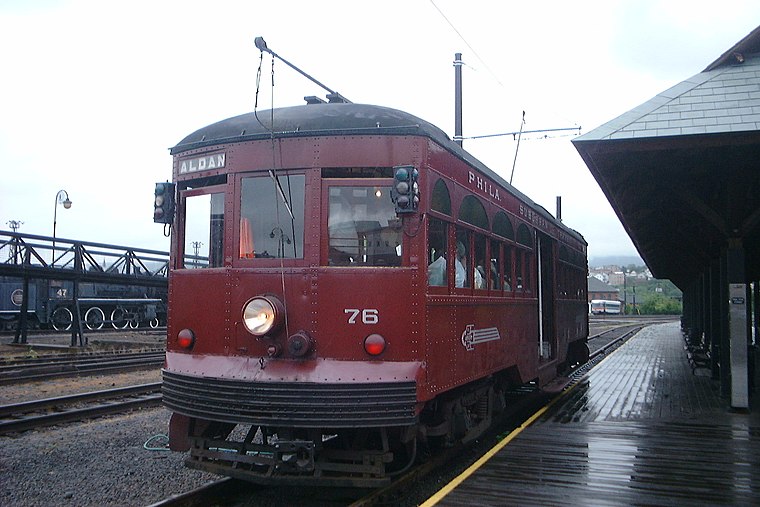
Photo: Peter Van den Bossche, CC BY-SA 2.0.
The Electric City Trolley Museum is a transport museum located in downtown Scranton, Pennsylvania, next to the Steamtown National Historic Site. The museum displays and operates restored trolleys and interurbans on former lines of the Lackawanna and Wyoming Valley Railroad, which are now owned by the government of Lackawanna County and operated by the Delaware-Lackawanna Railroad. Electric City Trolley Museum is situated 1,500 feet northwest of Diesel Fuel Storage Containment Ring.
Steamtown National Historic Site
Protected area

Photo: Wikimedia, Public domain.
Steamtown National Historic Site is a railroad museum and heritage railroad located on 62.48 acres in downtown Scranton, Pennsylvania, at the site of the former Scranton yards of the Delaware, Lackawanna and Western Railroad.
Places in the Area
Nearby places include Scranton and Dunmore.
Scranton

Photo: Vasiliymeshko, CC BY-SA 4.0.
Scranton is a city in Northeastern Pennsylvania. It is near Wilkes-Barre, and is the seventh most populous city in the state. Today, it is perhaps best known as the setting of the hit TV show "The Office" and the birthplace of Joe Biden, the 46th President of the United States.
Dunmore

Photo: Doug Kerr, CC BY-SA 2.0.
Dunmore is a borough in Lackawanna County, Pennsylvania, United States, adjoining Scranton. It is part of Northeastern Pennsylvania and was settled in 1835 and incorporated in 1862.
Throop
Village

Photo: Smallbones, CC0.
Throop is a borough in Lackawanna County, Pennsylvania, United States, adjoining Scranton. Formerly, coal mining and silk manufacturing provided employment for the people of Throop, who numbered 2,204 in 1900 and 5,133 in 1910. Throop is situated 4½ miles northeast of Diesel Fuel Storage Containment Ring.
Diesel Fuel Storage Containment Ring
- Type: Building
- Category: historic site
- Location: City of Scranton, Lackawanna County, Pennsylvania, Mid-Atlantic, United States, North America
- View on OpenStreetMap
Latitude
41.40682° or 41° 24′ 25″ northLongitude
-75.66939° or 75° 40′ 10″ westOpen location code
87H6C84J+P6OpenStreetMap ID
way 445922016OpenStreetMap feature
building=storage_tankOpenStreetMap feature
historic=yesOpenStreetMap feature
man_made=storage_tank
This page is based on OpenStreetMap, Wikidata, and Wikimedia Commons.
We’d love your help improving our open data sources. Thank you for contributing.
Satellite Map
Discover Diesel Fuel Storage Containment Ring from above in high-definition satellite imagery.
Notable Places Nearby
Highlights include Mine Storage Building foundation and 1902 Roundhouse & Technology Museum.
Nearby Places
Explore places such as Green Sand Drying Tower and Diesel Fuel Storage Containment Ring.
Pennsylvania: Must-Visit Destinations
Delve into Philadelphia, Pittsburgh, Harrisburg, and Scranton.
Curious Buildings to Discover
Uncover intriguing buildings from every corner of the globe.
About Mapcarta. Data © OpenStreetMap contributors and available under the Open Database License". Text is available under the CC BY-SA 4.0 license, except for photos, directions, and the map. Photo: Nicholas A. Tonelli, CC BY 2.0.