Variskarit
Variskarit is an island in Vaasa, Ostrobothnia. Variskarit is situated nearby to the locality Isolahden venesatama, as well as near the suburb Viikinga.| Tap on a place to explore it |
Places of Interest
Highlights include Ostrobothnian Museum and Vaasa Main Library.
Ostrobothnian Museum
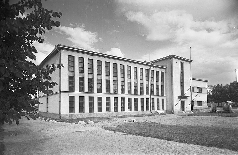
Museum

Photo: Wikimedia, Copyrighted free use.
The Ostrobothnian Museum is a provincial museum of cultural history, which also serves as provincial art museum and a museum of natural science. The museum building, designed by Eino Forsman in 1927, and the museum’s exhibition wing, planned by architect Erik Kråkström in 1967 are located next to the Marianpuisto park in central Vaasa.

Places in the Area
Nearby places include Korsholm and Hietalahti.
Korsholm
Town

Photo: Htm, CC BY-SA 3.0.
Vaasa is the capital of the administrative region Ostrobothnia, Western Finland. The surrounding municipality of Korsholm is also handled in this article.
Hietalahti
Suburb

Photo: Zunter, CC BY-SA 4.0.
Hietalahti is a neighbourhood in the city of Vaasa, Finland. The neighbourhood officially consists of two subdivisions, 9th and 10th districts, of Vaasa.

Variskarit
- Type: Island
- Categories: coastline, locality, and landform
- Location: Vaasa, Vaasa, Ostrobothnia, West Coast, Finland, Nordic countries, Europe
- View on OpenStreetMap
Latitude
63.12° or 63° 7′ 12″ northLongitude
21.5926° or 21° 35′ 33″ eastOpen location code
9GM34H9V+X2OpenStreetMap ID
way 4498429OpenStreetMap feature
natural=coastlineOpenStreetMap feature
place=island
This page is based on OpenStreetMap, Wikidata, and Wikimedia Commons.
We’d love your help improving our open data sources. Thank you for contributing.
Satellite Map
Discover Variskarit from above in high-definition satellite imagery.
In Other Languages
From Finnish to Swedish—“Variskarit” goes by many names.
- Finnish: “Variskarit”
- Swedish: “Kråknäsgrund”
Localities in the Area
Explore places such as Isolahden venesatama and Viikinga.
Notable Places Nearby
Highlights include Variskarin puisto and Huvilatien leikkialue.
Ostrobothnia: Must-Visit Destinations
Delve into Jakobstad, Kristinestad, Kaskinen, and Närpes.
Curious Islands to Discover
Uncover intriguing islands from every corner of the globe.
About Mapcarta. Data © OpenStreetMap contributors and available under the Open Database License". Text is available under the CC BY-SA 4.0 license, except for photos, directions, and the map. Photo: Jjtkk, Public domain.