Umspannwerk Arcisstraße
Umspannwerk Arcisstraße is an industrial building in Munich, Upper Bavaria, Bavaria. Umspannwerk Arcisstraße is situated nearby to the school Gisela Gymnasium, as well as near the marketplace Elisabethmarkt.| Tap on a place to explore it |
Places of Interest Nearby
Highlights include Academy of Fine Arts, Munich and Alte Pinakothek.
Academy of Fine Arts, Munich
University
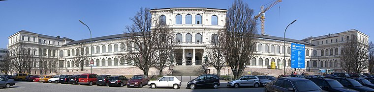
Photo: Wikimedia, CC BY-SA 3.0.
The Academy of Fine Arts, Munich is one of the oldest and most significant art academies in Germany. It is located in the Maxvorstadt district of Munich, in Bavaria, Germany. Academy of Fine Arts, Munich is situated 580 metres southeast of Umspannwerk Arcisstraße.
Alte Pinakothek
Museum

Photo: Wikimedia, CC BY-SA 3.0.
The Alte Pinakothek is an art museum located in the Kunstareal area in Munich, Germany. It is one of the oldest galleries in the world and houses a significant collection of Old Master paintings. Alte Pinakothek is situated 1 km south of Umspannwerk Arcisstraße.
Schauburg
Theater building

Photo: Rufus46, CC BY-SA 3.0.
Schauburg is a theatre in Munich, Bavaria, Germany. From 1967 to 1972 the internationally renowned nightclub Blow Up resided in the building, which was Germany's first large-scale disco. Schauburg is situated 180 metres northeast of Umspannwerk Arcisstraße.
Places in the Area
Nearby places include Maxvorstadt and North Munich.
Maxvorstadt

Photo: Tbp386, CC BY-SA 3.0.
Maxvorstadt is the arts and university district of Munich, just north of Altstadt the historic city centre.
North Munich

Photo: Tbp386, CC BY-SA 3.0.
Northern Munich is a large expanse of the city of Munich bounded to the north by A99 autobahn, to the east by the river Isar, and to the west and south by the railway tracks running from the airport to city centre.

Umspannwerk Arcisstraße
- Type: Industrial building
- Categories: building and industry
- Location: Munich, Upper Bavaria, Bavaria, Germany, Central Europe, Europe
- View on OpenStreetMap
Latitude
48.15624° or 48° 9′ 23″ northLongitude
11.57378° or 11° 34′ 26″ eastOperator
Stadtwerke MünchenOpen location code
8FWH5H4F+FGOpenStreetMap ID
way 455414138OpenStreetMap feature
building=industrial
This page is based on OpenStreetMap, Wikidata, and Wikimedia Commons.
We’d love your help improving our open data sources. Thank you for contributing.
Satellite Map
Discover Umspannwerk Arcisstraße from above in high-definition satellite imagery.
Notable Places Nearby
Highlights include Gisela Gymnasium and Elisabethmarkt.
Nearby Places
Explore places such as True Society and Weil.
Munich: Must-Visit Destinations
Delve into North Munich, Altstadt, Haidhausen, and Ludwigsvorstadt-Isarvorstadt.
Curious Industrial Buildings to Discover
Uncover intriguing industrial buildings from every corner of the globe.
About Mapcarta. Data © OpenStreetMap contributors and available under the Open Database License". Text is available under the CC BY-SA 4.0 license, except for photos, directions, and the map. Photo: Heav84, CC BY-SA 3.0.