Colegio Mayor Jesús-María
Colegio Mayor Jesús-María is a residential building in Granada, Granada, Andalusia which is located on Calle Profesor Clavera. Colegio Mayor Jesús-María is situated nearby to the sports venue Centro de Actividades Deportivas de la Cartuja, as well as near the park Parque del Agua.| Tap on a place to explore it |
- Type: Residential building
- Address: Calle Profesor Clavera 8
- Roof shape: flat
- Wheelchair access: yes
Places of Interest Nearby
Highlights include Alhambra and Andalusian School of Public Health.
Alhambra
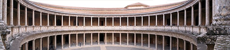
Photo: Bernd Untiedt, CC BY-SA 3.0.
The Alhambra is a palace and fortress complex located in Granada, Spain. It is one of the most famous monuments of Islamic architecture and one of the best-preserved palaces of the historic Islamic world. Alhambra is situated 1½ km southeast of Colegio Mayor Jesús-María.
Andalusian School of Public Health
Public building
The Andalusian School of Public Health is a Spanish public institution which provides training, consultancy and research services for the health care sector. Andalusian School of Public Health is situated 300 metres east of Colegio Mayor Jesús-María.
Generalife

Photo: Jean-Pierre Dalbéra, CC BY 2.0.
The Generalife was a summer palace and country estate of the Nasrid rulers of the Emirate of Granada in Al-Andalus. It is located directly east of and uphill from the Alhambra palace complex in Granada, Spain. Generalife is situated 2 km southeast of Colegio Mayor Jesús-María.
Places in the Area
Nearby places include Albaicín and Pajaritos.
Albaicín
Quarter

Photo: Miguel303xm, CC BY-SA 2.5.
The Albaicín, also spelled Albayzín, is a neighbourhood of Granada, Spain. It is centered around a hill on the north side of the Darro River which passes through the city.

Sacromonte
Neighborhood
 Sacromonte, sometimes also called Sacramonte, is a traditional neighbourhood in the eastern area of the city of Granada in Andalusia, Spain. It is one of the six neighbourhoods that make up the urban district of Albayzín and borders the neighbourhoods of Albayzín, San Pedro, Realejo-San Matías, El Fargue and Haza Grande.
Colegio Mayor Jesús-María
Latitude
37.19015° or 37° 11′ 25″ northLongitude
-3.59783° or 3° 35′ 52″ westLevels
8Open location code
8C9R5CR2+3VOpenStreetMap ID
way 458320081OpenStreetMap feature
building=residentialOpenStreetMap attribute
roof-shape=flatOpenStreetMap attribute
wheelchair=yes
This page is based on OpenStreetMap, Wikidata, and Wikimedia Commons.
We’d love your help improving our open data sources. Thank you for contributing.
Satellite Map
Discover Colegio Mayor Jesús-María from above in high-definition satellite imagery.
Notable Places Nearby
Highlights include Centro de Actividades Deportivas de la Cartuja and Parque del Agua.
Nearby Places
Explore places such as Profesor Clavera - Frente a Alojamientos Universitarios and Profesor Clavera - Alojamientos Universitarios.
Granada: Must-Visit Destinations
Delve into Almuñécar, Alhama de Granada, Portugos, and La Alpujarra.
Curious Residential Buildings to Discover
Uncover intriguing residential buildings from every corner of the globe.
About Mapcarta. Data © OpenStreetMap contributors and available under the Open Database License". Text is available under the CC BY-SA 4.0 license, except for photos, directions, and the map. Photo: Ogre, Public domain.