FIZ 11.0
FIZ 11.0 is an office building in Munich, Upper Bavaria, Bavaria. FIZ 11.0 is situated nearby to the metro station Am Hart station, as well as near BMW Group Research and Innovation Center.| Tap on a place to explore it |
Places of Interest Nearby
Highlights include Am Hart station and Hinterhoftheater.
Am Hart station
Metro station

Photo: Wikimedia, CC BY-SA 4.0.
Am Hart is an U-Bahn station in Munich on the U2. Am Hart station is situated 100 metres east of FIZ 11.0.
Hinterhoftheater
Theater building
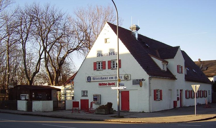
Photo: Gamsbart, CC BY-SA 3.0.
Hinterhoftheater is a theatre in Munich, Bavaria, Germany. Hinterhoftheater is situated 460 metres east of FIZ 11.0.
BMW Group Research and Innovation Center

Photo: Gamsbart, CC BY 3.0 de.
The BMW Group Forschungs- und Innovationszentrum is the main engineering and development campus of the BMW Group. It is located in Milbertshofen-Am Hart, a district in northern Munich. BMW Group Research and Innovation Center is situated 190 metres south of FIZ 11.0.
Places in the Area
Nearby places include Am Hart and Virginia-Depot.
Am Hart
Suburb

Photo: FlocciNivis, CC BY 4.0.
Am Hart is the northernmost of the three sub-districts of the Munich city district 11 Milbertshofen-Am Hart.
Virginia-Depot
Locality
The Virginia depot was a military camp used last by the Bundeswehr west of Schleißheimer Straße in the Munich district of Lerchenau. Today it is a biotope with rare plant species.
Harthof
Suburb
Harthof is a district in the north of the Bavarian capital Munich. It is located in districts 11 Milbertshofen-Am Hart and 24 Feldmoching-Hasenbergl. Harthof consists of medium-sized housing estates and an estate of older council flats.
FIZ 11.0
- Type: Office building
- Roof shape: flat
- Categories: building and office
- Location: Munich, Upper Bavaria, Bavaria, Germany, Central Europe, Europe
- View on OpenStreetMap
Latitude
48.19585° or 48° 11′ 45″ northLongitude
11.57041° or 11° 34′ 14″ eastLevels
4Open location code
8FWH5HWC+85OpenStreetMap ID
way 4590676OpenStreetMap feature
building=officeOpenStreetMap attribute
roof-shape=flat
This page is based on OpenStreetMap, Wikidata, and Wikimedia Commons.
We’d love your help improving our open data sources. Thank you for contributing.
Satellite Map
Discover FIZ 11.0 from above in high-definition satellite imagery.
Notable Places Nearby
Highlights include Münchner Volkshochschule Stadtbereichszentrum Nord and Polizeiinspektion München 47 (Milbertshofen).
Nearby Places
Explore places such as FIZ 10.0 and FIZ 12.0.
Munich: Must-Visit Destinations
Delve into North Munich, Altstadt, Haidhausen, and Ludwigsvorstadt-Isarvorstadt.
Curious Office Buildings to Discover
Uncover intriguing office buildings from every corner of the globe.
About Mapcarta. Data © OpenStreetMap contributors and available under the Open Database License". Text is available under the CC BY-SA 4.0 license, except for photos, directions, and the map. Photo: Heav84, CC BY-SA 3.0.