Haus der Wiener Wirtschaft
Haus der Wiener Wirtschaft is a retail building in Inner East, Vienna which is located on Straße der Wiener Wirtschaft. Haus der Wiener Wirtschaft is situated nearby to the government office Wirtschaftskammer Wien, as well as near Anitta-Müller-Cohen-Platz.| Tap on a place to explore it |
- Type: Retail building
- Address: Straße der Wiener Wirtschaft 1, Wien, 1020
- Roof shape: flat
Places of Interest Nearby
Highlights include Wien Praterstern railway station and Giant Ferris Wheel.
Wien Praterstern railway station
Railway station
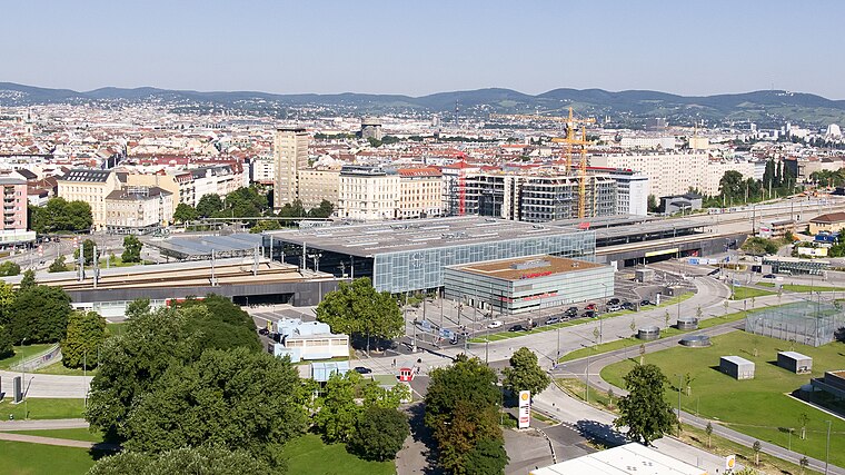
Photo: Wikimedia, Public domain.
Wien Praterstern is one of Vienna's main railway stations, used by 35,000 people daily. It is located on the roundabout Praterstern in Leopoldstadt, in the north of the city. Wien Praterstern railway station is situated 210 metres south of Haus der Wiener Wirtschaft.
Giant Ferris Wheel
Ferris wheel

Photo: Rftblr, CC BY-SA 4.0.
The Wiener Riesenrad, or simply Riesenrad, is a 64.75-metre tall Ferris wheel at the entrance of the Prater amusement park in Leopoldstadt, the 2nd district of Austria's capital Vienna. Giant Ferris Wheel is situated 530 metres southeast of Haus der Wiener Wirtschaft.
Praterstern station
Metro station

Photo: Gryffindor, Public domain.
Praterstern is a station on U1 and U2 of the Vienna U-Bahn. Above the U-Bahn station is the Wien Praterstern railway station, which is served by regional trains, and by lines S1, S2, S3 and S7 of the Vienna S-Bahn. Praterstern station is situated 130 metres south of Haus der Wiener Wirtschaft.
Places in the Area
Nearby places include Volkertviertel and Stuwerviertel.


Haus der Wiener Wirtschaft
- Category: building
- Location: Inner East, Vienna, Austria, Central Europe, Europe
- View on OpenStreetMap
Latitude
48.22091° or 48° 13′ 15″ northLongitude
16.39262° or 16° 23′ 33″ eastInception
April 15th, 2019Levels
9Operator
Wirtschaftskammer WienOpen location code
8FWR69CV+92OpenStreetMap ID
way 479826612OpenStreetMap feature
building=retailOpenStreetMap attribute
roof-shape=flat
This page is based on OpenStreetMap, Wikidata, and Wikimedia Commons.
We’d love your help improving our open data sources. Thank you for contributing.
Satellite Map
Discover Haus der Wiener Wirtschaft from above in high-definition satellite imagery.
Notable Places Nearby
Highlights include Wirtschaftskammer Wien and Anitta-Müller-Cohen-Platz.
Nearby Places
Explore places such as Bank Austria and Praterstern.
Vienna: Must-Visit Destinations
Delve into Innere Stadt, Vienna International Airport, Alsergrund, and Hietzing.
Curious Retail Buildings to Discover
Uncover intriguing retail buildings from every corner of the globe.
About Mapcarta. Data © OpenStreetMap contributors and available under the Open Database License". Text is available under the CC BY-SA 4.0 license, except for photos, directions, and the map. Photo: Wikimedia, CC BY-SA 3.0.