ž.zast. Cihelna
ž.zast. Cihelna is a shelter in Litoměřice, Ústí nad Labem Region. ž.zast. Cihelna is situated nearby to Litoměřice Cihelna railway stop, as well as near Luna Bowling.| Tap on a place to explore it |
Places of Interest Nearby
Highlights include St. Stephen’s Cathedral and Church of Saint Adalbert.
St. Stephen’s Cathedral
Church
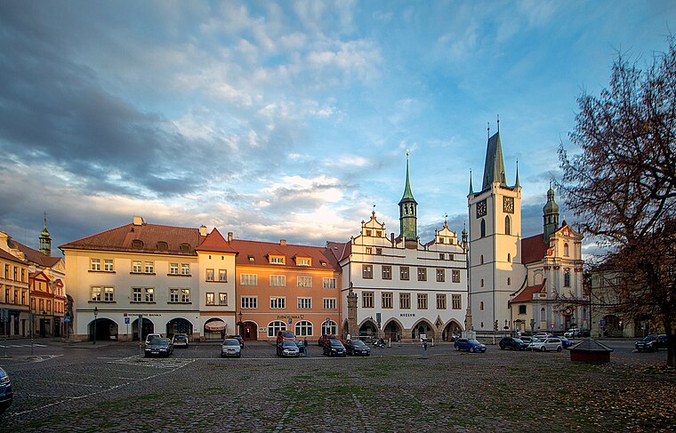
 The St. Stephen's Cathedral or simply Cathedral of Litoměřice, is the name given to a religious building of the Catholic Church that works as a cathedral of the Diocese of Litoměřice, and is also one of the most important cultural sites in the city. St. Stephen’s Cathedral is situated 1 km southeast of ž.zast. Cihelna.
Church of Saint Adalbert
Church

Photo: H2k4, CC BY-SA 3.0.
Church of Saint Adalbert is situated 640 metres east of ž.zast. Cihelna.
Litoměřice horní nádraží railway station
Railway station
 Litoměřice horní nádraží is a railway station in Litoměřice, Czech Republic. The station is located north of the city centre and serves regional trains to Most, Postoloprty and Česká Lípa on lines U10 and U11. Litoměřice horní nádraží railway station is situated 1 km northeast of ž.zast. Cihelna.
Places in the Area
Nearby places include Za nemocnicí and Litoměřice-Město.

Mlékojedy
Village

Photo: Miaow Miaow, Public domain.
Mlékojedy is a municipality and village in Litoměřice District in the Ústí nad Labem Region of the Czech Republic. It has about 200 inhabitants. Mlékojedy lies approximately 16 km south of Ústí nad Labem and 54 km north-west of Prague.
ž.zast. Cihelna
Latitude
50.53705° or 50° 32′ 13″ northLongitude
14.11826° or 14° 7′ 6″ eastOpen location code
9F2PG4P9+R8OpenStreetMap ID
way 483640939OpenStreetMap feature
amenity=shelter
This page is based on OpenStreetMap, Wikidata, and Wikimedia Commons.
We’d love your help improving our open data sources. Thank you for contributing.
Satellite Map
Discover ž.zast. Cihelna from above in high-definition satellite imagery.
Notable Places Nearby
Highlights include Litoměřice Cihelna railway stop and Luna Bowling.
Nearby Places
Explore places such as Litoměřice Cihelna and Pramen.
North Bohemia: Must-Visit Destinations
Delve into Liberec, Ústí nad Labem, Teplice, and Děčín.
Curious Shelters to Discover
Uncover intriguing shelters from every corner of the globe.
About Mapcarta. Data © OpenStreetMap contributors and available under the Open Database License". Text is available under the CC BY-SA 4.0 license, except for photos, directions, and the map. Photo: Karelj, Public domain.