konv. Ferkel-, Mast-, Sauenstall
konv. Ferkel-, Mast-, Sauenstall is a building in Lower Saxony, Germany. konv. Ferkel-, Mast-, Sauenstall is situated nearby to the forest Bruch, as well as near the nature reserve Fehlingsbleck.| Tap on a place to explore it |
Places of Interest Nearby
Highlights include Scharnebeck and Fehlingsbleck.
Scharnebeck
Government office

Photo: Raboe001, CC BY-SA 3.0 de.
Scharnebeck is a municipality in the district of Lüneburg, in Lower Saxony, Germany. It is situated approximately 10 kilometres northeast of Lüneburg. The Scharnebeck twin ship lift on the Elbe Lateral Canal is in the municipality. Scharnebeck is situated 4 km south of konv. Ferkel-, Mast-, Sauenstall.

Bennerstedt
Nature reserve

Photo: Egydius, CC BY-SA 4.0.
Bennerstedt is a nature reserve, which is situated 2½ km west of konv. Ferkel-, Mast-, Sauenstall.
Places in the Area
Nearby places include Brietlingen and Hohnstorf.
Brietlingen
Village
Brietlingen is a municipality in the district of Lüneburg, in Lower Saxony, Germany. Brietlingen is situated 4½ km west of konv. Ferkel-, Mast-, Sauenstall.
Hohnstorf
Village
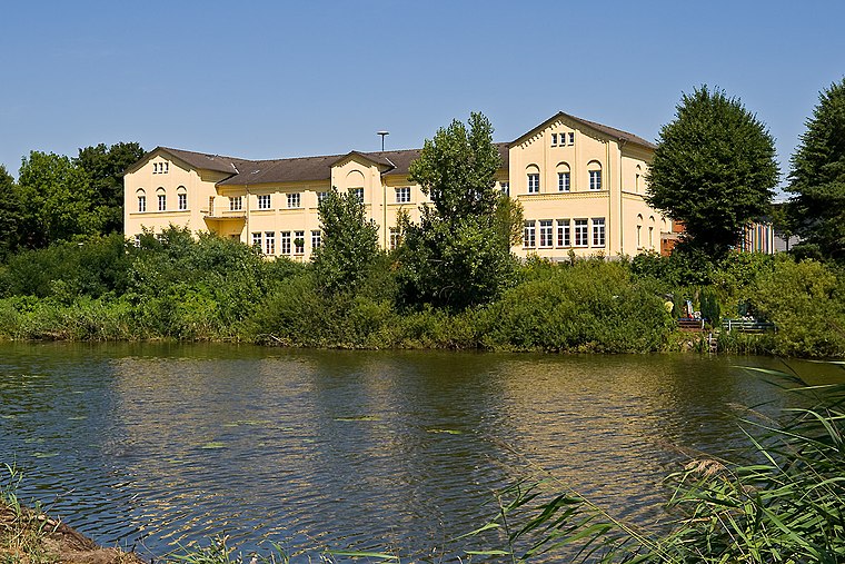
Photo: Torsten Bätge, CC BY-SA 3.0.
Hohnstorf is a municipality in the district of Lüneburg, in Lower Saxony, Germany. Hohnstorf is situated 5 km northeast of konv. Ferkel-, Mast-, Sauenstall.
Artlenburg
Village

Photo: Warrel040, CC BY-SA 4.0.
Artlenburg is a municipality in the district of Lüneburg, in Lower Saxony, Germany. Artlenburg has an area of 11.85 km2 and a population of 1,619. Artlenburg is situated 5 km north of konv. Ferkel-, Mast-, Sauenstall.
konv. Ferkel-, Mast-, Sauenstall
- Type: Building
- Location: Lower Saxony, Germany, Central Europe, Europe
- View on OpenStreetMap
Latitude
53.32701° or 53° 19′ 37″ northLongitude
10.51649° or 10° 30′ 59″ eastOpen location code
9F5G8GG8+RHOpenStreetMap ID
way 486540520OpenStreetMap feature
building=yes
This page is based on OpenStreetMap, Wikidata, and Wikimedia Commons.
We’d love your help improving our open data sources. Thank you for contributing.
Satellite Map
Discover konv. Ferkel-, Mast-, Sauenstall from above in high-definition satellite imagery.
Notable Places Nearby
Highlights include Bruch and Freiwillige Feuerwehr Echem.
Nearby Places
Explore places such as LBZ Echem and Besucher.
Lower Saxony: Must-Visit Destinations
Delve into Hanover, Göttingen, Brunswick, and Wolfsburg.
Curious Buildings to Discover
Uncover intriguing buildings from every corner of the globe.
About Mapcarta. Data © OpenStreetMap contributors and available under the Open Database License". Text is available under the CC BY-SA 4.0 license, except for photos, directions, and the map. Photo: Danapit, CC BY-SA 3.0.