Schutzhütte des Goslarer Handwerks
Schutzhütte des Goslarer Handwerks is a shelter in Goslar, Southern Lower Saxony, Lower Saxony. Access is restricted and requires permission. Schutzhütte des Goslarer Handwerks is situated nearby to the peak Steinberg, as well as near the pitch Tischtennisraum.| Tap on a place to explore it |
Places of Interest Nearby
Highlights include Imperial Palace of Goslar and Goslar station.
Imperial Palace of Goslar
Castle

Photo: Wikimedia, Public domain.
The Imperial Palace of Goslar is a historical building complex at the foot of the Rammelsberg hill in the south of the town of Goslar north of the Harz mountains, central Germany. Imperial Palace of Goslar is situated 1¼ km southeast of Schutzhütte des Goslarer Handwerks.
Goslar station
Railway station
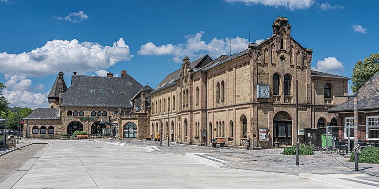 Goslar is a railway station located in Goslar, Germany. The station opened on 23 March 1866 and is located on the Vienenburg–Goslar railway, Hildesheim–Goslar railway and Neuekrug-Hahausen–Goslar railway. Goslar station is situated 1 km northeast of Schutzhütte des Goslarer Handwerks.
Mönchehaus-Museum für Moderne Kunst
Historic house

Photo: Markscheider, CC BY-SA 4.0.
Mönchehaus-Museum für Moderne Kunst is a historic house, which is situated 1 km east of Schutzhütte des Goslarer Handwerks.
Places in the Area
Nearby places include Steinberg and Altstadt.


Schutzhütte des Goslarer Handwerks
- Access is restricted and requires permission.
- Type: Shelter
- Categories: building and hut
- Location: Goslar, Goslar, Southern Lower Saxony, Lower Saxony, Germany, Central Europe, Europe
- View on OpenStreetMap
Latitude
51.9083° or 51° 54′ 30″ northLongitude
10.40979° or 10° 24′ 35″ eastOpen location code
9F3GWC55+8WOpenStreetMap ID
way 490420443OpenStreetMap feature
amenity=shelterOpenStreetMap feature
building=hut
This page is based on OpenStreetMap, Wikidata, and Wikimedia Commons.
We’d love your help improving our open data sources. Thank you for contributing.
Satellite Map
Discover Schutzhütte des Goslarer Handwerks from above in high-definition satellite imagery.
Notable Places Nearby
Highlights include HWN 111 - Steinbergturm/Steinbergalm and Aussichtsturm Steinberg.
Nearby Places
Explore places such as Steinberg Relais DB0GSH and Haus Zeppelin.
Southern Lower Saxony: Must-Visit Destinations
Delve into Göttingen, Hamelin, Hann. Münden, and Einbeck.
Curious Shelters to Discover
Uncover intriguing shelters from every corner of the globe.
About Mapcarta. Data © OpenStreetMap contributors and available under the Open Database License". Text is available under the CC BY-SA 4.0 license, except for photos, directions, and the map. Photo: Wikimedia, CC0.