Campus Frankfurt University of Applied Sciences
Campus Frankfurt University of Applied Sciences is a square in Frankfurt, South Hesse, Hesse. Campus Frankfurt University of Applied Sciences is situated nearby to the library Gebäude 3: Bibliothek, as well as near the park Nibelungenallee.| Tap on a place to explore it |
Places of Interest Nearby
Highlights include Old Jewish Cemetery and Bürgerhospital Frankfurt am Main.
Old Jewish Cemetery
Cemetery

Photo: Dontworry, CC BY-SA 3.0.
The Old Jewish Cemetery of Frankfurt, Germany, is located at Rat-Beil-Straße directly adjacent to the oldest parts of the gentile Frankfurt Main Cemetery. Old Jewish Cemetery is situated 290 metres north of Campus Frankfurt University of Applied Sciences.
Bürgerhospital Frankfurt am Main
Hospital

Photo: Dontworry, CC BY-SA 3.0.
Bürgerhospital Frankfurt am Main is situated 450 metres west of Campus Frankfurt University of Applied Sciences.
City Gate
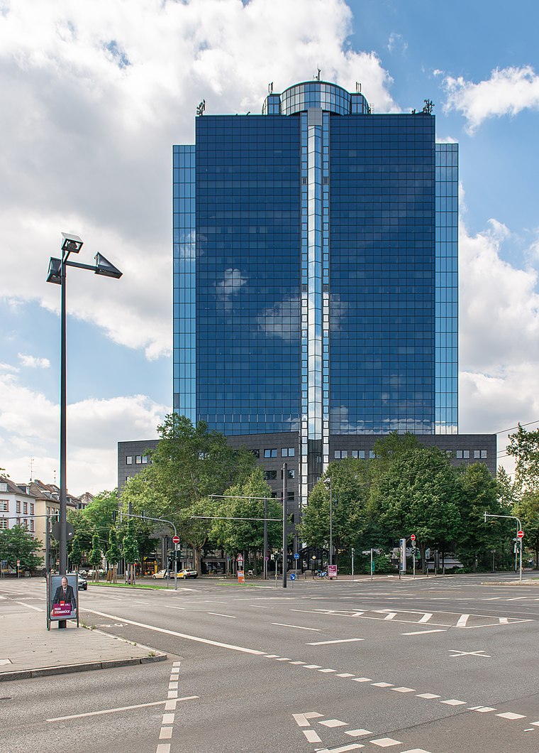
Photo: Epizentrum, CC BY-SA 3.0.
City Gate, formerly Büro Center Nibelungenplatz and Shell Tower, is a 27-storey, 110 m skyscraper in the Nordend-West district of Frankfurt, Germany. The building was constructed in 1966. City Gate is situated 200 metres south of Campus Frankfurt University of Applied Sciences.
Places in the Area
Nearby places include Westend and Bahnhofsviertel.
Westend
Suburb

Photo: Wikimedia, CC BY-SA 3.0.
Westend-Nord and Westend-Süd are two city districts of Frankfurt am Main, Germany. The division into a northern and a southern part is mostly for administrative purposes as the Westend is generally considered an entity. Westend is situated 3 km southwest of Campus Frankfurt University of Applied Sciences.
Bahnhofsviertel
Suburb

Photo: Luisfff2812, CC BY 4.0.
The Bahnhofsviertel is a quarter of Frankfurt am Main, Germany. It is part of the Ortsbezirk Innenstadt I. The Bahnhofsviertel was developed between 1891 and 1915. Bahnhofsviertel is situated 3 km southwest of Campus Frankfurt University of Applied Sciences.
Sachsenhausen
Suburb
Sachsenhausen-Nord and Sachsenhausen-Süd are two quarters of Frankfurt am Main, Germany. The division into a northern and a southern part is mostly for administrative purposes as Sachsenhausen is generally considered a single entity. Sachsenhausen is situated 3½ km south of Campus Frankfurt University of Applied Sciences.
Campus Frankfurt University of Applied Sciences
- Type: Square
- Category: locality
- Location: Frankfurt, South Hesse, Hesse, Germany, Central Europe, Europe
- View on OpenStreetMap
Latitude
50.13049° or 50° 7′ 50″ northLongitude
8.69267° or 8° 41′ 34″ eastOpen location code
9F2C4MJV+53OpenStreetMap ID
way 507328056OpenStreetMap feature
place=square
This page is based on OpenStreetMap, Wikidata, and Wikimedia Commons.
We’d love your help improving our open data sources. Thank you for contributing.
Satellite Map
Discover Campus Frankfurt University of Applied Sciences from above in high-definition satellite imagery.
Notable Places Nearby
Highlights include Frankfurt University of Applied Sciences and Gebäude 3: Bibliothek.
Nearby Places
Explore places such as Gebäude 6: Kinderhaus and Café Kurzschlusz.
South Hesse: Must-Visit Destinations
Delve into Darmstadt, Bensheim, Lorsch, and Heppenheim.
Curious Squares to Discover
Uncover intriguing squares from every corner of the globe.
About Mapcarta. Data © OpenStreetMap contributors and available under the Open Database License". Text is available under the CC BY-SA 4.0 license, except for photos, directions, and the map. Photo: Mylius, GFDL.